Table of Contents
Orbit MM Update 10.4 - January 2013
Feature Summary of the January 7th, 2013 update.
- Latest Release : Orbit Mobile Mapping Update 11.0 - June 2014
- Other Orbit Updates : Orbit Update Overview
Version 10.4 includes a major update regarding 3D viewing with intuitive roaming and measuring of point clouds, catenary measurement
and an upgrade of the OPC file format for use of large datasets.
Installation
The latest release can be downloaded from the Orbit website.
Orbit Desktop Installation and License Request
Orbit Desktop Asset Inventory Installing Updates
Do not overwrite a previous installation with a new version!
Some configurations are changed and will cause
conflict with previous settings resulting in runtime errors.
New Features
Redesigned Standalone
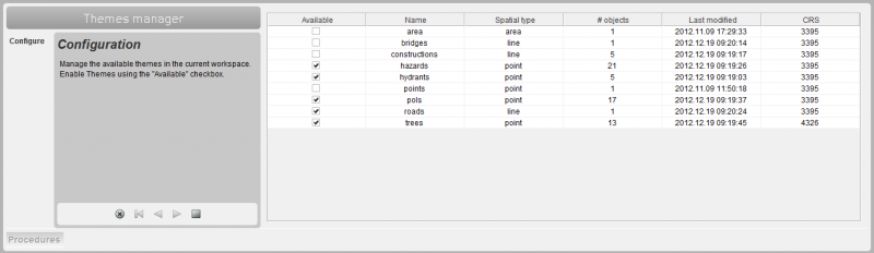
Manage Theme procedure
Added procedure to manage a stand-alone AIM3 version using file storage instead of database.
Multiple independent workspaces
The Orbit AIM3 standalone starts with a default workspace, but new workspaces can be created to your preferences.
Themes are manged by Orbit and can be added to every single workspace using the Manage theme procedure.
Mobile Mapping Runs and Projects can not be saved by default in a workspace but will always be available from the Open Project and Open Run procedures.
File-based inventories
Inventory themes are now stored on your file system in Orbit vector files (.ovf). No RDBMS (database) is required to operate which simplifies installation, especially on 64bit.
This has two important consequences :
- No database connection needs to be established, no worries anymore about the available database drivers.
- Direct access to inventory themes for editing the dataset properties, attribute structure and legend.
GPS Photography
To simplify the installation and the use of workspaces the GPS photography extension has been removed from the default download.
If interested, this extension can be added to the standalone configuration (send email to support at orbitgis dot com).
Link to documentation :
Advanced Spatial Viewer for Point Cloud and Panoramas
Orbit AIM 10.4 introduces a powerful 3D Viewer for any Mobile Mapping resource. No restrictions on file size nor functionalities :

- Displaying huge point clouds at once but also 3D and 2D vector data can be displayed.
- View point clouds and vector data in Stereo.
- All Asset Inventory and Measure functionalities can be used both in the Panorama View and the 3D View.
- An intelligent navigation has been implemented to use the 3D View.
- This new View component has been integrated in the existing Orbit AIM application in a smart way, easy to use..
Link to documentation :
Upgrade Point Cloud format
Version 10.4 includes a major upgrade of the Orbit point cloud format “OPC”.

- Huge point clouds (tested up to +250GB) can be viewed and used at once.
- Measurements in point clouds are no longer limited to a 50 meter distance from the viewing point, when using the new point cloud format. This restriction remains in place for the previous point cloud format.
New and Optimized Measure functionalities
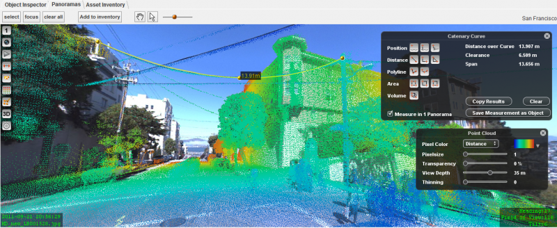
Catenary Curve Measurement
With tree simple clicks a catenary curve, span and clearance can be measured and saved.
Optimization of Point Cloud measurements
Orbit will auto-calculate the best possible measurement using the principles of triangulation between all selected point cloud points. The used algorithm is refined for using on compact and HD point clouds.
Copy measure result to clipboard, paste any value to attribute
Panorama measure functions remain available while using the asset inventory procedures. This enables the possibility to copy and paste additional measurement values into an attribute while creating or editing assets. A single click on the measure result in the measure HUD copies its value onto the clipboard.
Move measurement point
While measuring it is possible to move a single measured point or “vertex”. Hoovering the mouse above a measured point will indicate that one can click and drag to move the vertex.
This is possible after finishing the measurement as well when editing asset inventory objects.
Edit Inventory item
Direct activation of the measure function when choosing to “Draw on panoramas”. The measure hud and additional actions aren't required to start measuring the inventory object. This action is similar to the “Add inventory item” procedure.
Link to documentation :
Improved management of Mobile Mapping data
Manage Run templates
The available templates for importing mobile mapping data into Orbit Runs can be configured.
Templates can be freely added to the list of available types. This can be very useful when using data from different mobile mapping systems or when using different setups of your system.
List status of Runs in Project
From the Mobile Mapping extension tab in the EOS Console (in Client-Server only) it is possible to check the availability of all runs used in a project. Missing run data will be displayed with the red status icon.
Delete Project files
When removing a mobile mapping project using the administrator procedure “Remove Project”, the project configuration directory and files will be deleted as well. This will avoid having obsolete files in your file system.
Removing a run will never delete the run folder nor data. Removed runs can be re-imported with a single action as all required conversions remain on disc.
Customized Legend for Project Photo Positions
Using the standard Orbit GIS legend and labeling tools a customized legend for a Mobile Mapping Projects can be generated and saved.
This was in previous versions already possible for Mobile Mapping Runs.
Name check
The entered name for new Runs and Projects is checked to avoid network problems due to invalid characters.
Only characters, numbers, spaces, dash - and underscore '_' will be accepted.
Link to documentation :
Improvements on Panoramas and Point Cloud Dislpaly
Point Cloud display
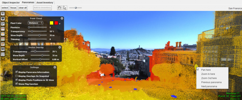
- Pixel Color palettes
The fix color or from-to colors (default yellow and red) could already be set to your preference.
In version 10.4 , 2 additional color scheme pallets were added for nice range displays.
Vector overlays
- View depth Slider
The view depth slider makes steps of 5 meter from 10 to 60 meter. This instead of 4 meter steps (14, 18, …, 50) between 10 and 50. - Reduce Vector Overlay
Reducing the view depth of displayed objects is possible. In previous versions once objects were displayed it wasn't possible anymore to remove them from overlay by reducing the view depth. - Improved display Area objects
Minor rarities with Area vector overlays are fixed. - Default transparency
The default transparency for vector overlays on panoramas is set to 10 instead of 50%, this increases the default visibility of overlays. - Direct legend refresh
Overlayed features will be refreshed instantly when changing an attribute value used for legend classification. In the case of an attribute classification, changing the value will directly refresh the object presentation.
Huds / Overlay Windows (Measure, Vector Overlay, Point Cloud preferences)
- Close with click
Huds on Panoramas or 3D View can be closed with a new click on the corresponding icon. - Bugfix Invisible Huds
Opened panorama huds (measure, vector overlay) are no longer visible / available after minimizing the Orbit main window.
Solution : Bug fixed, minimizing the Orbit main window doesn't affect the opened huds.
Snapshots
- Snapshots
Using the Snapshot functionality Panorama and Point Cloud are be default visible on the snapshot (if visible in the view of course). Using the flag “Display Overlays on Snapshot” one can define to display all visible overlays (Vector overlays, measurements, additional information).
Link to documentation :
Improved Usability
Improvements on Panorama and Mobile Mapping data
- Create Run
Newly imported Runs from type “Generic” are directly available for use, no Orbit AIM3 restart is required. - Remote Projects
Possibility to open and use (online) remote Orbit projects with spaces in naming.
Improvements on Asset Inventory
- Retained Object ID
The export and import theme procedures preserve the Object ID. This makes a complete copy of a theme possible in an easy way, including snapshot photos and documents. - Value lists edits
A selected value from a drop-down list will automatically be applied. A deselect of the attribute field is not required anymore. - Search Inventory items
Search and selection from Inventory items using the Asset Inventory search function is enabled within the Edit inventory item procedure. This makes it easier to search for items that needs to be edited.
Other Improvements
- Recent file location
Consistently use of the recent file location for selecting a file or indicating a directory. Export theme, import theme, create run, create project.
Reporting inconsistent use of a recent location is appreciated.
Link to documentation :
Bug Fixes
- Occasionally occurring error while measuring long polylines.
Solution : if one of the vertex measurements of the polyline has no measure result, the operator will need to redo this vertex measurment but can continue measuring the polyline. - Too many database tasks when using the inventory procedures with multiple operators.
Solutions : Orbit manages more efficient database connectivity. In case of using MySQL a reconfiguration of the MySQL service is recommended.
- Displaying OpenStreetMap or other image resources on panoramas blocks all other feature vector overlays.
Solution : Image resources can not be overlayed on panoramas, but they can still be used in the 3D view mode. - Sometimes the point Cloud preferences could not be modified anymore . Bug fixed.
- Under certain conditions from the workspace removed resources were re-opened automatically. Bug fixed.
- Editing 3D objects, initially measured on Panoramas or Point cloud, on the 2D MapCanvas could remove a part of the object. Bug fixed.