This is documentation of an archived release.
For documentation on the current version, please check Knowledge Base.
For documentation on the current version, please check Knowledge Base.
Tools Overview

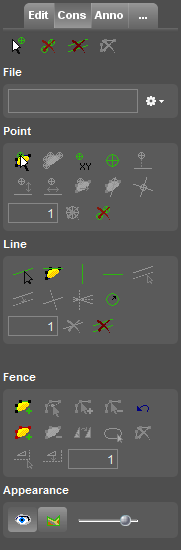
The Map 2D Tools Sidebar provides access to all Orbit's standard tools for spatial editing, constructions, annotations and others like image and raster processing.
| Edit Tools | Construction Tools | Annotation Tools | Additional Tools |
|---|---|---|---|
| Tools to create and edit vector data. | Tools to add constructions to assist high accurate vector editing. | Tools for annotation and redlining. Quickly add some remarks on the 2D Map and exchange these. | A list of tools available on the 2D Map. |
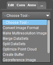
| Create & Edit Objects Overview Edit Tools Sidebar Snap function | Constructions Overview Construction Tools Sidebar | Annotations Overview Annotation Tools Sidebar | Convert Imagery Optimize Imagery Create Buffer Georeference Image and Vector Make Symbol Library Image Make Legend Display Image Convert Point Cloud Optimize Point Cloud Convert Vector Data Optimize Vector Data Spatial Join |
 |  |  |  |
Last modified:: 2019/03/25 11:36