For documentation on the current version, please check Knowledge Base.
Spatial Join
This page describes the additional tool “Spatial Join”.
![]() Map 2D > Tools > … > Spatial Join
Map 2D > Tools > … > Spatial Join
A type of join operation in which fields from one layer's attribute table are appended to another layer's attribute table based on the relative locations of the features in the two layers. A Spatial join is a GIS operation that affixes data from one feature layer’s attribute table to another from a spatial perspective.
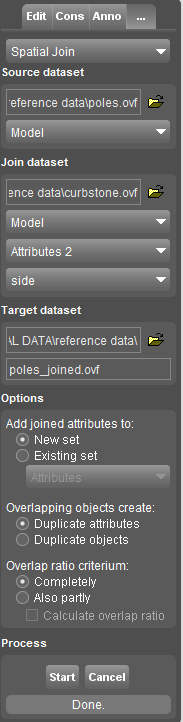
Source Dataset
The dataset that you are joining to. The output of the join operation will contain the objects from this feature class with appended columns from the join dataset. You can chose the model, if your dataset has more then one
Join Dataset
The dataset that you are joining from. The attributes from this dataset are appended to the attributes of the target dataset in the output based on a spatial relation.You can choose the “Model”, The “AttributeSet”, or each Attribute that you want to join.
Target Dataset
A new dataset which contains the results of the join operation, you can choose the name and location.
Options
Some little tools to define how your operation will be carried out. You can choose if your new attributes will be stored in a new attribute set or not, what to do in case of overlaps based the degree of the overlap.
Process
Press start to initiate the proccedure.