Table of Contents
Starting with Orbit Mobile Mapping
Orbit Mobile Mapping desktop Interface
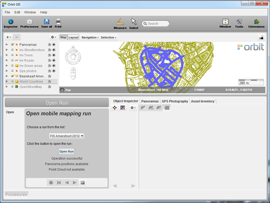
Select project
Choose a mobile mapping project from the drop-down list with available projects.
Open project
Click the <Open Project> button to load the selected project.
The Map will zoom to the extents of the opened mobile mapping project. If available the image positions will be displayed on map.
Close procedure
Apply and confirm by clicking the square button (square).
Cancel and undo by clicking the cross button (cross).
Introduction
Asset Inventory Management from Mobile Mapping
The Orbit Asset Inventory Management solution combines a series of modules and techniques that are perfectly integrated to generate an easy to use solution for a wide variety of inventories, combining position, photography, status, documentation and more. Direct integration with Mobile Mapping content empowers each user to access rich information at a click.
Orbit's AIM solution is ready for production and consultancy, feature extraction and overlays, stand-alone, client/server or internet based.
Mobile Mapping Systems support
Current version support mobile mapping data from all major manufacturers and setups, such as Topcon, Riegl, Optech, Trimble, 3DStreetMapper, MDL, ScanLook, Cyclomedia, FIS, earthmine and others. It also supports a generic import for panoramic images, planar images and point clouds.
For download and product information :
Download and Install
Orbit AIM (standalone) can be downloaded from our website. Read all information here : Orbit Desktop Installation and License Request
It is recommended to read these remarks before installing Orbit Asset Inventory :

Import Mobile Mapping Data
Current version supports mobile mapping data from Topcon IP-S2, Cyclomedia, FIS, Trimble and earthmine. It also supports a generic import for panoramic images and point clouds.
Read all information about importing Mobile Mapping data here :
Open an imported Mobile Mapping Project
Once your Mobile Mapping data has been imported, it can be easily re-opened :
Use and Measure in Panoramas and Point Cloud
Orbit AIM provides an user-friendly interface for viewing, using and measuring on Panoramas and Point cloud.
Start from this page to explore these features : View and Use Mobile Mapping data

Start Asset Inventory
Once your data is imported in Orbit, it can be used for Asset inventory : Asset Inventory Management
Orbit GIS
Orbit Mobile Mapping solutions are based on Orbit' GIS engine “Orbit GIS”. This native integration offers wide capabilities of support for traditional vector and image GIS data.
The basic GIS documentation can be found here : Orbit Core Desktop Framework