This is documentation of an archived release.
For documentation on the current version, please check Knowledge Base.
For documentation on the current version, please check Knowledge Base.
GIS Resources
This page gives a short overview about GIS resource types. Much more on the world wide web. An overview of all supported formats can be reviewed here.
GIS data represent real objects (such as roads, land use, elevation, trees, waterways, etc.). These objects can be digitally pictured in various ways.
Traditionally, there are three broad methods used to store spatial data.
| Vector Data | Raster Data | Image Data |
|---|---|---|
 A vector file with points (9), lines (2) and areas (1). | 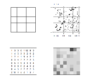 Using a raster to summarize a point pattern | 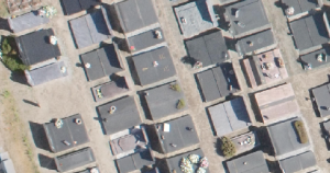 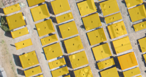 Detailed orthophoto used to create vector plan. |
| Spatial information stored as vertices (coordinates) that represent points, polylines (lines) or polygons (areas). Vertices can be combined to vectors (segments), multiple consecutive segments (lines) or closed polylines (areas). | Quantitative spatial information stored as numeric values (samples) organized in a cell matrix or grid (pixels). Each pixel has one sample (e.g. height, reflection, … ) | Spatial information stored as numeric values (samples) organized in a cell matrix or grid (pixels). These pixel values represent a color. Each pixel has one or more samples (e.g. red, green and blue). Bits/Sample, Samples/Pixel, Bits/Pixel : Image type 1, 1, 1 : Monochrome, black-white 8, 1, 8 : Grayscale 8, 3, 24 : RGB (red green blue) 8, 4, 32 : ARGB (alpha/transparency RGB) |
| Supported Formats | ||
| File based Resources | ||
| OVF / OVT / SHP / GPX / KML / KMZ FME Resources (DWG, DXF, DGN, … ) | OMI / DEM / ERS / FLT / HGT / IMG / RST | Image Data OIF / BMP / GIF / JPG / PNG Multiresolution Image Data OMI / ECW / SID / JP2 / TIF |
| Web based Resources | ||
| WFS | inapplicable | WMS, WMTS, TMS |
| Database Resources - Spatial Databases | ||
| WKT / WKB / Oracle Spatial / PostgreSQL | inapplicable | inapplicable |
| Related documentation | ||
| Vector dataset structure concepts | Multiresolution Image data Make Multiresolution Image Convert Image Format |
|
Last modified:: 2019/03/25 11:36