

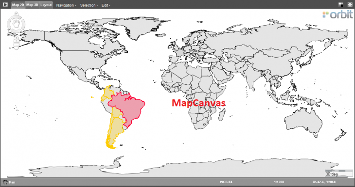
The MapCanvas is the center of Orbit to view and interact with all your resources.
| Generic functions | |
|---|---|
| Status Bar | Displays the activated function, the CRS of the MapCanvas, the scale and the coordinates of the cursor position in the current CRS |
| Backdrop | Toggles the background color from white to black, useful to detect white colored vector objects. 1) |
The activated function is indicated by the appearance of the cursor above the map and in the left lower corner of the Map status bar. Review icons in footnote2).
| Map Functions | |
|---|---|
| Compass Rose | Provides all features to navigate the MapCanvas in a single useful widget |
| Pan Functions | Move the MapCanvas to optimize the view of the 2D Map |
| Zoom Functions | Zoom in or zoom out the MapCanvas |
| Rotate Functions | Rotate the orientation of the MapCanvas, zoom level and center of the MapCanvas will not be modified |
| Select Functions | Activate the select function and select objects from datasets |
| Measure Functions | Measure lines, circles, perpendicular distances and angles |
| Search Function | Search for objects and open the find objects tool |
| Context Menu | Right-click on the map to open the context menu and to navigate or export the MapCanvas view |
The activated function is indicated by the appearance of the cursor above the map and in the left lower corner of the Map status bar. 3)
| Map Functions | |
|---|---|
| Compass Rose | Provides all features to navigate the MapCanvas in a single useful widget |
| Pan Functions | Move the MapCanvas to optimize the view of the 3D Map |
| Zoom Functions | Zoom in or zoom out the MapCanvas |
| Select Functions | Activate the select function and select objects from datasets |
| Measure Functions | Measure points, lines, area and volumes on the 3D Map |
| Context Menu | Right-click on the 3D Map to open the context menu and to navigate or export the MapCanvas view |
The activated function is indicated by the appearance of the cursor above the map and in the left lower corner of the Map status bar.
| Print Layout Functions | |
|---|---|
| Print Layout | Provides all features to make a print of the MapCanvas and make a matching layout. |
 , Select
  , Zoom In
  , Zoom Out
  , Zoom Smart
  , Rotate
  , Edit / Measure