Mobile Mapping Top and Side Toolbar
This page describes one by one all the functions and icons or the Mobile Mapping tab Top and Side toolbar.
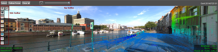
Mobile Mapping Top Toolbar
![]() Tabs > Mobile Mapping
Tabs > Mobile Mapping
Select
The leftmost “Select” button activates the function to open one or more mobile mapping views by clicking on the Map 2D.
It is one button, but it can be used in different ways to open on the most efficient way the view you want :
Follow Focus
The “Follow Focus” button activates the function to focus (pan / heading) all opened panorama views (not 3D views) to the specified Map 2D location by clicking and dragging on the Map 2D.
Clear all
A single click on the “Close all” button will close all opened views.
Pan
The pan button (hand) activates the mobile mapping pan function to navigate on an opened image or 3D view.
It is one button, but wit a lots of possibilities to navigate smooth and easy on images and in 3D :
Brightness slider
The slider on the right adjusts the image brightness for all opened image views.
This slider will be useful when using pictures taken by changing weather condition or varying illumination.
Mobile Mapping Side Toolbar
![]() Tabs > Mobile Mapping > Open View
Tabs > Mobile Mapping > Open View


View Reference and Close View
Reference or link with the panorama position on the MapCanvas.
When moving the mouse cursor above the reference number, the reference number will change to a close icon.
A single click will close the current Panorama view.


3D View shortcuts
The 3D view shortcuts can be combined with the <Ctrl> button. A normal click will adjust the zoom using all visible data in the Mobile Mapping view as reference. Combined with <Ctrl> the 3D viewpoint (XYZ) will be retained, only tilt and heading will be adjusted.
- Get topview : tilt -90°
- Get oblique view : tilt -45° but retain heading
- Get streetview : tilt 0°

Make Snapshot
Copy exactly the current Panorama view to the clipboard and paste the snapshot in another application.
The visibility of overlays (photo positions, vector objects, attribute measurements, photo and view information) on snapshots is a generic mobile mapping view setting, available via the setting icon in the sidebar of the leftmost mobile mapping view.


Play / Walk-through
Auto play through panoramas. Continuously the next panorama within the panorama field of view will be displayed.
Field of View and Tilt will remain unchanged.
Once the play function is started the stop icon will appear. A single click will stop the auto play function.

Open Measure Window
Start the measure procedure for measuring points, lines and areas on the panoramas using point cloud or by triangulation.
More information : Measure in Mobile Mapping data.

Open Vector Overlay Window
Group of parameters regarding the presentation of vector object overlays on panoramas.
Datasets can only be displayed when the dataset coordinate reference system is defined.
More information : Vector Overlays on Mobile Mapping data.
- Transparency : Adjust the transparency of overlayed objects.
- View Depth : The maximum distance from the photo position for overlayed objects.
- Vertical Offset : Vertical adjustment on calculated Z value only applied for 2D datasets. For objects from 2D datasets
a virtual Z will be calculated on the fly using the Z of the photo position and the height of the camera.
3D objects will always be displayed using their Z-value.
More information : Consulting the object Z-values, Defining 2D and 3D datasets.


Point Cloud Preferences
Group of parameters regarding the presentation of the point cloud on panoramas.
Adjust on the fly and without loading the visualization parameters of the displayed point cloud.
For displaying the point cloud use the icon above. If no point cloud is available this icon will be grayed out.
- Pixel Color : Select a fix color, use the RGB value (if available) or classify the point cloud by using Height, Distance or Intensity.
When classifying the point cloud based on Height, Distance or Intensity the minimum and maximum values
are always calculated on the fly for the currently displayed part of the point cloud.
The fix color or from-to colors (default yellow and red) can be set to your preference. A single click on the color box will open
the Color picker window. New in Orbit AIM 10.4 are the 2 from-to pallets for a nice classification. - Pixelsize : Define the size of the point cloud pixels.
- Transparency : Adjust the transparency of displayed point cloud.
- View Depth : The maximum distance from the photo position for the displayed point cloud.
- Thinning : Display all or less pixels from the point cloud. This can be useful when using HD point clouds.


Point Cloud Visibility
A point cloud can only be displayed when the Orbit Client has direct file access to the point cloud.
If no point cloud is available this icon will be grayed out.


Switch Mobile Mapping View
Change the mobile mapping view mode : image view, 3d view, 3d view stereo and 3d view isometric.


Open Trajectory Window
Group of parameters regarding display of trajectory.
- Display trajectory : Flag to show the trajectory on the Map 2D and in the Mobile Mapping 3D view.
The trajectory will not be displayed in the mobile mapping Image view. - Min-Max Slider : Slider to set the minimum and maximum accuracy threshold.
The accuracy threshold can only be defined if an accuracy indicator has been imported.

Open Settings Window
Group of parameters regarding additional overlays on panoramas.
- Display Photo Positions : Display the panorama and planar photo positions in the mobile mapping views.
- Display View Information : The Image file name and time stamp are displayed in the lower-left corner of the image.
The current viewing specifications are displayed in the lower-right corner of the image.
Heading and Field of view are also nicely represented in the pie-slice alike representation for each selected
panorama on the MapCanvas.- Heading : Orientation for the center of the image (north = 0).
- Tilt : deviation from horizontal view in DEG.
- Field of View : Width of the viewing angle in DEG.
- Include Overlays on Snapshot : Visualize overlays (point cloud, measurements, dataset objects and panorama information) on the snapshot,
created using the second panorama side icon.