For documentation on the current version, please check Knowledge Base.
Dataset General Properties
The Storage Properties panel contains information about the username and projection of the dataset. It also manages the global scale limits.
![]()
Right-Click on the dataset in the Datasets & Dataset Lists > Dataset Context Menu > Dataset Properties > General
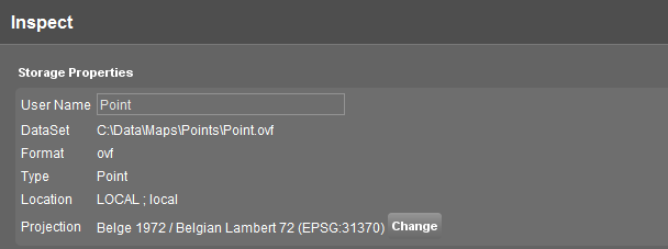
| Storage Properties | |
|---|---|
| Username | This is the name of the dataset as displayed in the Datasets & Dataset Lists. By entering a new name the username can be changed easily. |
| DataSet | Shows the location of the dataset on the computer or the Registry Name of the dataset defined by the EOS-Console. |
| Format | Shows the format of the dataset. (ovf, shp, omi,…) |
| Location | Shows the locationtype of the dataset: Local or EOS. |
| Projection | Shows the Coordinate Reference System of the dataset. If no CRS is set the projection will be “undefined”. Click the “Change” button to set or modify the dataset CRS. More information about the dataset CRS, read Coordinate Reference Systems in Orbit. |
Scale Limits
Scale Limits ensure that the dataset is visible when the view on the MapCanvas is between a specified scale range. Outside the scale range the dataset remains invisible.
When the dataset is invisible, the name of the dataset displayed in the Datasets & Dataset Lists appears in italics.
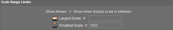
Choose whether the dataset must be displayed always or to use Scale Limits.
When chosen Scale Limits, enter a Largest and/or Smallest Scale.
More information about Scale Limits see Scale Limits