For documentation on the current version, please check Knowledge Base.
Vector Overlays on Mobile Mapping data
An overlay is a Dataset that is displayed in the Mobile Mapping views.
Orbit can overlay any supported vector resource.
Overlaying Image resources is not supported.
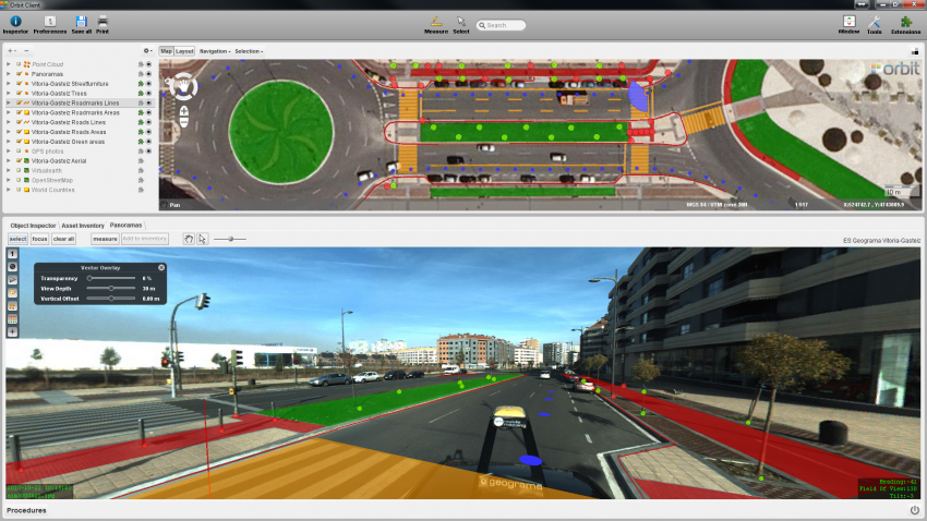
Overlaying Datasets
From the Orbit desktop Client, 2 possibilities :
- Right click the dataset in the dataset list and select the last option “Display in Mobile Mapping”1).
- Click the Extensions icon (puzzle piece) right from the dataset in the dataset list.
If the Extensions icon is not visible you can make this available from the Dataset List preferences.
From the Orbit web Client, turn on the visibility on Panoramas from the Vector Overlay Window
Visible objects
The Dataset doesn't need to be visible on the Map to be overlayed in the Mobile Mapping views.
The overlayed dataset objects are limited by the vector overlay view depth.
The view depth calculation is slightly different for an image View and a 3D mobile mapping view :
- image views : distance from the overlayed objects to the view position, the image position.
- 3D views : distance from the overlayed objects to ground level position of the current 3D view.
Object Height
3D Dataset
Objects from 3D datasets are overlayed as is. The display height will be derived from their Z co-ordinates.
2D Dataset
To project a 2D dataset in a 3D environment, a Z-value will be calculated for the dataset and applied on all its objects.
This value is calculated from the image height (in planar or panorama view) or the downwards point cloud intersection (in 3D point cloud view if no image has been opened yet). When using imagery the Orbit run metadata contains the height of the camera sensor above ground level. Using this height above ground, a 2D dataset will be displayed as laying 'on the ground'.
The calculated ground height of the 2D datasets can be adjusted using the vertical offset slider from the vector overlay window :
Mobile Mapping Top and Side Toolbar
Datastruture definition
If the Z value for all objects is equal to 0.0 and the Orbit dataset structure is defined as 3D, then most probably the vector overlay height will not be as expected.
As the dataset is defined as being 3D orbit will use the object Z to display the object in the 3D environment. Consequently all objects aren't displayed at the expected ground level, most probably far below.
Check the Object Z values (1) and define the appropriated datastructure (2) :
- Object Inspector > Object Focus > Spatial Component
- Dataset Structure Contents > Structure > Manage Models in Dataset > Coordinate
Dataset Coordinate system
To combine and overlay GIS and Mobile Mapping resources stored in different coordinate reference systems, all used coordinate systems need to be well defined.
The CRS of the mobile mapping run should be well set. This is set in the mobile mapping import template and needs to be provided by your data provider :
The CRS of the overlayed datasets need to be specified properly so Oribt can perform the reprojection to display the objects on top of imagery and or point cloud :
- Coordinate Reference Systems in Orbit > Dataset CRS
Overlay Problems and Accuracy
Symbols upside-down
When using symbols as graphical presentation of point features, these symbols may be displayed upside-down in the mobile mapping views2).
If this occurs use the dataset legend, symbol size option “Draw icons 1:1” to display the icons correctly, see All Point Legend Parameters.
CRS
Objects will not be overlayed if the dataset CRS of the overlayd resoucres is not defined, see topic above.
Objects will be not visible because of displayed far below ground level if the spatial type is defined mistakenly as 3D (default for shape files!!), see topic above.
Accuracy
Overlays and Panorama's may not match as expected. There is a 2 issues to take into account. The overlay accuracy will be the result of both, which may result in an error larger than expected.
- the accuracy of the panorama positions
- the accuracy of the dataset objects