Prepare Aerial Data Leica RCD30
This page describes aerial nadir data from Leica RCD30 medium format aerial camera.
Using the corresponding template from 3D Mapping Data Preparation and Import Templates the described resources can be imported into Orbit.
It is strongly recommend to read first Concepts about Mobile Mapping data in Orbit.
Nadir Images
Image files
- Image type : Undistorted (corrected distortion and Central Principal Point) planar images.
- File format : Each image is one *.jpg file.
- File name : Exactly as in image positions file, see below.
- Folder structure : All files in one folder.
Image Positions File
- File format : One ascii file.
- File structure Rows : each image is one record.
- File structure Columns : space separated (char32), with exact order as the example below.
- Value of Filename : File name as on disk, without file extension.
- Value of Coordinates : any supported coordinate system can be used, Long/Lat order for geographical coordinates, decimal notation, without thousands separator.
- Value of Angles “Omega;Phi;Kappa” : Omega, Phi, Kappa orientation angles, degrees.
# imageName Long/X Lat/Y Z Omega Phi Kappa
20160929_113_id241c1_241_172256648_rgb 513043.497 9753930.469 389.120 0.40093 4.72046 27.90815
20160929_113_id242c1_242_172259116_rgb 513092.679 9753835.287 387.020 1.29137 5.07739 29.08409
20160929_113_id243c1_243_172301647_rgb 513143.792 9753737.737 385.486 -0.17540 4.77806 28.52107
...
Camera calibration file
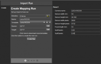
The camera calibration parameters must be entered before Create Run, the 1st step of the Import Run procedure.
To facilitate import, your specific camera calibration values can be registered inside the Orbit template to avoid entering these values at import each time. Contact Orbit Support if assistance is needed.
Point Cloud
- File format : One or more *.las files.
- File structure : Las version 1.2.
Orthomosaic
- File format : Any supported image data format.
The ortho is not a part of the UAS Mapping Run, it can be added separately to the Map view.
Convert the Orthomosaic file into *.omi format for enhanced performance.