Table of Contents
Dataset Context Menu
Right-click a dataset to open the dataset context menu.

| Function | Description | |
|---|---|---|
| Dataset Properties | Opens the Dataset Properties Window of the selected dataset. There is access to various items through the tabs. Default the tab “General” is opened, where it is possible to view and/or edit general information from the dataset: user and unique name, format (*.ovf, *.omi, *.shp, …) and type (points, lines, areas, image or mixed) and scale range limits. |
|
| Attribute Table | Opens the Attribute Table View of the selected dataset. | |
| Join Tables | Opens Join Tables Window to join external data with the selected dataset. | |
| Labels | Opens the Labeling Editor to edit the labels of the selected dataset that represent attribute values. | |
| Legend Editor | Opens the Legend Editor to edit the appearance of the selected dataset. | |
| Charts Editor | Opens the Charts Editor to edit the pie charts of the selected dataset. | |
| View Metadata | View the Metadata of the selected dataset. | |
| Show Legend Display | Display the legend of the selected dataset in the Dataset List. | |
| SoloView | Only view the selected dataset, temporary hide all other datasets. | |
| SoloSafe | This dataset will always be visible, even if another dataset is set to Soloview | |
| Zoom To Dataset Extent | Zoom to overview all objects of the selected dataset. It is interesting to use the Dataset Extent Function when the location of the dataset-objects is unknown. |
|
| Arrange | Change the display order of the dataset. It is also possible to drag and drop a datast in the DataSet List to change its order. |
|
| Bring to Front | Bring the selected dataset to the top of the dataset list. | |
| Bring Forward | Bring the selected dataset one place up in the dataset list. | |
| Send Backward | Send the selected dataset one place down in the dataset list. | |
| Send to Back | Send the selected dataset to the bottom of the dataset list. | |
| Set Scale Limits | Set Dataset Scale limits to display the dataset. More information below. | |
| Coordinate Reference System | Define or Transform the dataset coordinate system. All information about coordinate systems can be read here : Coordinate Reference Systems in Orbit |
|
| Define Dataset CRS | Declare / set / specify the dataset CRS. This will not convert the Dataset CRS. | |
| Convert Dataset CRS | Transfrom and Reproject the spatial component of the selected dataset. | |
| Convert Dataset to MapCanavs CRS | Transfrom and Reproject the spatial component of the selected dataset to the current MapCanvas CRS. | |
| Save Dataset As | Save the selected datataset (image or vector resources) with another name but using the same storage format and resource specifications (e.g. image compression). | |
| Export Dataset To | Export the selected Dataset (vector resources only) and specify file name and supported format. To export an image resource use the Convert Image tool. |
|
Dataset Scale Limits
Scale Limits can be imposed on a Dataset to restrict viewing of the data within a scale range. Zooming outside the scale range will render the Dataset invisible, regardless its visibility setting. Its name will appear italic in the Dataset List.
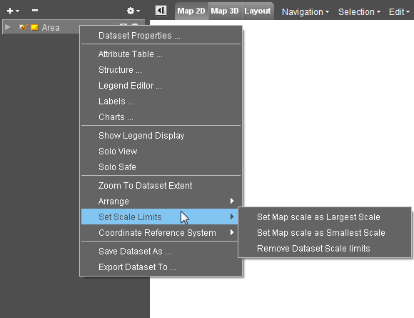
- Set current as Largest Scale: Defines the most detailed view limit of the scale range. Zoom In is limited to this scale. The Dataset Properties are automatically adjusted.
- Set current as Smallest Scale: Defines the overview limit of the scale range. Zoom out is limited to this scale. The Dataset Properties are automatically adjusted.
- Remove Scale limits: The scale range is cleared and scale limits are no longer imposed. The dataset will be drawn at all scales.
More Information about Scale Limits see: Scale Limits