For documentation on the current version, please check Knowledge Base.
2D Map Component
This page explains how to use the 2D Map Component of the HTML5 Viewer.
Search on Map
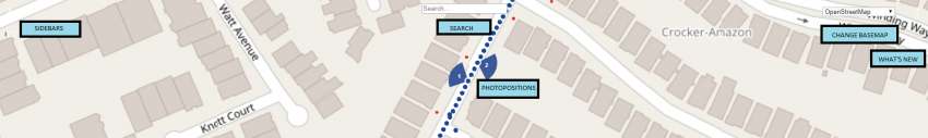
The Search Box drop down on top of the Map Component gives access to all available search engines as configured by the administrator.
Using this entry field it is possible to search for a location and open the closest image. A successful search request will center and zoom the map to the returned bounding box and update the left most image view focusing to the requested location. If no bounding box is returned by the search engine the map will be centered only.
Geocode
Enter address or location specifications according the capabilities of the used geocode plugin.
Geocoding services are varied, and implementation cannot be standardized. Therefore Orbit delegate the implementation of a geocoding service to the administrator. Contact your administrator for more information.
Coverage
Displayed data coverage on Map depend the data type of available resources.
Mobile Mapping Photo Positions
The photo positions or recording locations are visible on the Map Component up to a map scale of 1/1,500.
Heading and field of view of all Mobile Mapping Views are represented in the pie-slice presentation on the map.
Photo positions can be turned on/off from the Resources Sidebar
Check the page “MM View > Navigate, Open and Close Views” for an overview of the navigate and open view functions.
Oblique Footprints
Footprints can be turned on/off from the Resources Sidebar
While navigating through the Oblique Views, the footprints of the active photo is displayed in the Map. The footprints display is synchronized with the movements of the mouse.
Basemaps
Available basemaps and vector overlays are managed by the Orbit administrator and can not be changed in the Web Viewer.
Any combination of Supported resources can be used as basemap.
Change basemaps
Using the drop-down list from the right upper corner of the 2D Map component it is possible to switch between available basemaps.
Vector overlays
Vector overlays can be turned on/off from the Resources Sidebar.
It is up to the administrator to define the available vector resources.
Note, a vector dataset may not be visible due to scale limit limitations.
Open Fullscreen
Opens the viewer in Fullscreen.
What's New
Opens the What's New sidebar. As the HTML5 Viewer is rapidly developed and new features are constantly added, the what's new sidebar provides the user with a detailed list of new features.