Table of Contents
Catalog
This page describes the desktop extension “Catalog” for Mobile Mapping.
Content Manager, Publisher Client
![]() Main Toolbar > Extensions > Catalog
Main Toolbar > Extensions > Catalog
Tabs > Catalog
Cloud Upload Tool
![]() Top Toolbar > Catalog
Top Toolbar > Catalog
Concepts
The mobile mapping “Catalog” extension gives a complete overview and detailed information of all mobile mapping runs and projects. The interactive combination of map (geographical information), table (overview) and sidebar (detailed information) result in a powerful mobile mapping management tool.
Status
Your mobile mapping resources go through series of steps from data collection to delivery and ready to be used for feature extraction.
Archive resources
Archive resources of finished projects to retain the current and relevant overview. In other words restrict resources to these your currently working on.
Archived resources are removed from the catalog table and are not available via the open run or open project procedures. But these resources remain available if needed via the “List Archived Runs” flag in the right upper corner. Archived resources can be unarchived any time.
Remove resources
Orbit never physically delete mobile mapping resources. Removing moible mapping data will never delete the original data nor the Orbit processed data. It only removes the connection between application and data.
Sidebar
View
Selection
Select
Select resources on Map 2D.
Activate the “Select Run” function and hover above the Map 2D. A resources is selectable if its name appears as label to the mouse pointer. The selected resources are highlighted on Map 2D and in the catalog table. They are also listed on top of the table to get a direct access to the overview information.
Open/Close
Open or close the selected runs.
Remove or Archive
A selected resource can be removed or archived. These buttons will be disabled if multiple resources are selected.
View Settings
Resource visibility
Define the mobile mapping resource type (runs or projects) you would like to use in the catalog.
Colors on Map 2D
Define the resource color on the Map 2D.
- Unique Colors : apply colors as defined in the catalog table.
- Color orfant runs : all runs not used by any project will be colored red.
- Color by status: apply colors based on the status of the run in the catalog table
Other options
- Show trajectory : the trajectory will be displayed on map 2D.
- Show names : names of each run will be displayed on map 2D.
- Show selection only: only the semected run will be displayed on map 2D
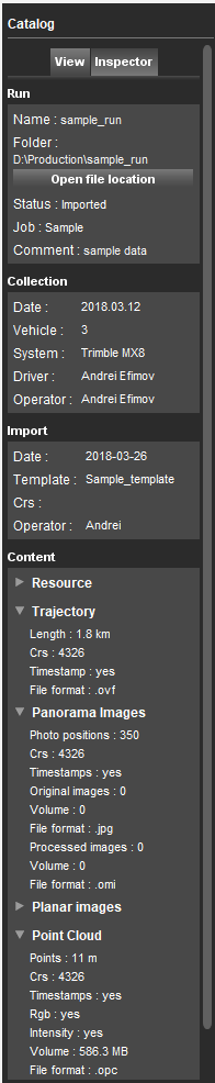
Inspector
The inspector tab1) displays detailed information of the selected mapping resource. All information at a glance:
- Run: General information, and via “Open file location” a shortcut to the files on disk.
- Collection : Metadata of data collection, can be completed via Import or Edit Run : Import 3D Mapping Data
- Import: Metadata of import
- Consolidate : Metadata of Consolidation, more specific reference to the original run or the names of the derived consolidated runs.
- Content: Metadata of the different components of the mobile mapping run or the lists of included runs in the selected project.
Tab
Overview
Use of Table
- Use the search box to filter on any available field. The restriction will be applied on <Enter>.
- Double click a table header name to sort.
- Use the “Archived Runs” checkbox to display archived runs.
- Right-click a single selected run record or multiple selected records to open the Catalog Context Menu.
Open and view resource
- Single click a table record to highlight the mobile mapping resource.
- Double click a table record to highlight and zoom to the extents of the mobile mapping resource.
- Change the color presentation on Map 2D with a single click on the color field. Note if a resource is selected in the catalog table, the selection preference focus color will be used.
- Open a selected Run or Project via the Catalog Context Menu or via the according button in the Catalog View Sidebar
The currently opened Run or Project is displayed in bold.
Contrary to open run or open project via procedures, the map will not zoom to the extents of the opened mobile mapping resource and, if available, trajectory information will be displayed immediately on the Map 2D. These two small differences make it possible to verify or compare the accuracy of multiple runs at the same location. Subsequently, segments can be adjusted or removed directly.
Table information
Available
The physical availability of the resource files (the connection to the data) is displayed by green / red indicator in the “Available” field.
Status
The status of your mobile mapping run is displayed by the status indicator :
- Imported, Added (yellow): a processed Orbit run has been added or raw data is imported.
- In process (red): run contains adjustments that aren't consolidated.
- Processed (grey): run was processed.
- Delivered (blue): run was delivered.
- Exported (green): run is an exported segment.
Numbers
- Trajectory: Length of the complete trajectory
- Panoramas#, Planars#: Number of photo positions / Number of Original Images / Number of Processed Images
- Paronamas%, Planars%: Percentage Original images / Percentage of Processed Images - in ratio to photo positions
- Point cloud: number of lidar points in the run, in millions
- Total Size: the size of data on disk, in gigabytes
HTML5 & Cloud
To check if Mapping Runs\Oblique Projects are HTML5 and Cloud-ready select Run\Project in the Catalog and with right-click “Calculate data volume” first and then “Calculate image availability”.
“Calculate data volume” checks if all the folders of the run have the expected amount of files in them. The amounts of image files are displayed in the catalog table.
“Calculate image availability” checks if the photo positions that are listed in the photo position file match the images in the run. If there is a mismatch, than one or more new files are created in the metadata folder of the run in which the mismatches are listed.
Icon indicating a Mapping Run is ready to upload to the 3DM Cloud.
- Red: not ready for upload.
- Yellow: minor issues.
- Green: ready for upload.
A tool-tip indicates the reason why the Mapping Run is not ready to upload. Reasons might be :
- Images are not optimized into processed images, see Optimize Imagery
- Number of processed images is less than the number of photo positions. For each photo position of the Mapping Run the corresponding optimized image must be available.
- Not all original images are optimized > Run the procedure Optimize Imagery again.
- Not all images are available > Remove the corresponding photo positions of the missing images.
- Resource directory (point cloud, panorama, planar, trajectory) is available but the data is not yet imported. Delete resource directory if the according resource not exists.
After resolving indicated by tool-tip issues, 'Calculate data volume' and 'Calculate image availability' again to check the HTML5 and Cloud-readiness status.
The Cloud-readiness status also indicates if the Mapping Run/Oblique Project can be used for publication in HTML5 Web Viewer and vice versa (naming will depend of the Orbit installed version). The Mapping Run/Oblique Project can not be published in HTML5 if the indicator is red.
Context menu
Open Edit Remove Run
See Manage Mapping Runs.
Consolidate Run
See Consolidation.
Add to Delivery, Remove from Delivery
See Delivery.
Archive and Unarchive
Archive resources of finished projects to retain the current and relevant overview. In other words restrict resources to these your currently working on.
Recalculate data volume
When importing a new run, it will become listed in the Catalog. However in order to see all above information and characteristics of a newly imported run, it is necessary to update the information in the Catalog.This is done by using the Recalculate data volume tool.