Table of Contents
Measure on Map 2D
The main toolbar Measure function can be used for measuring lengths or areas, circles, perpendicular distances and angles on the Orbit MapCanvas.
The measure results are expressed in the units used by the MapCanvas Coordinate system.
Note measuring on the MapCanvas is only possible when using a projected coordinate system.
- Activate the measure toolbar by clicking the measure button in the top toolbar

- Choose a measure function from the measure toolbar

 Length and Area
Click a series of points on the map view. The accumulative length and area (from the third point on) is calculated in real time and displayed in the measure toolbar. The measure indication is drawn on top of the map view. Right click the last point and choose “stop” or use the stop button to finish the measurement.

 Circle Radius and Area
Click once for the center and move your cursor around. The length (radius) and area (full circle) are calculated in real time and displayed in the measure window. The measure indication is drawn on top of the map view. Click again to fix the circle radius. Click one more time to start over.

 Perpendicular Distance
Click once at a first point of the help line, click once again at a second point of the help line. When the help line is set, automatically a perpendicular line is drawn. The perpendicular distance is displayed in the measure toolbar. Click once again to fix the perpendicular line. When you click the first time exactly at an already existing line, the help line is automatically drawn right on the existing line.
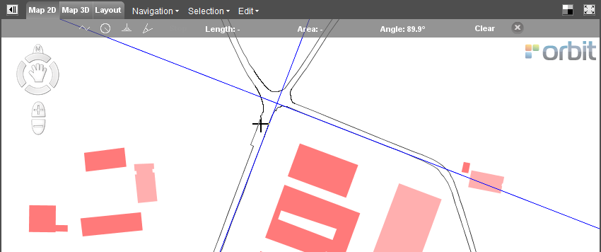
 Angle
Angle
The smallest angle between two lines will be calculated. First draw the first line by clicking at two points of the first line, then draw the second line by clicking at two points of the second line. The smallest angle between this two lines is then displayed in the measure toolbar. When you click the first time exactly at an already existing line, Orbit GIS will recognize this line and it will not be necessary to click twice to draw one line.
- Clear the measurement by clicking
 or close the measure toolbar by clicking
  .
.
Different measure results depending the used CRS
A measurement in metric units is always calculated in an projected Coordinate Reference System. Consequently you will have a different result for the same object measurement in different Coordinate System. The measurement depends of the properties of the projection in the measure area.
For example the Mercator projection conserves the angels, not the distances between different points. The distance increases closer to the poles. Have a look at the size of Greenland for example. It is about the same size as Saudi Arabia, about 2 million square kilometres.

© Source image : http://www.heliheyn.de/Maps/GallPeters/GallPeters_E.html
Read more about the Coordinate reference systems and the supported systems here :