For documentation on the current version, please check Knowledge Base.
Reference View
This page explains the Reference View of the 3D Mapping Cloud Viewer and 3DM Publisher HTML5 Viewer and how to use it.
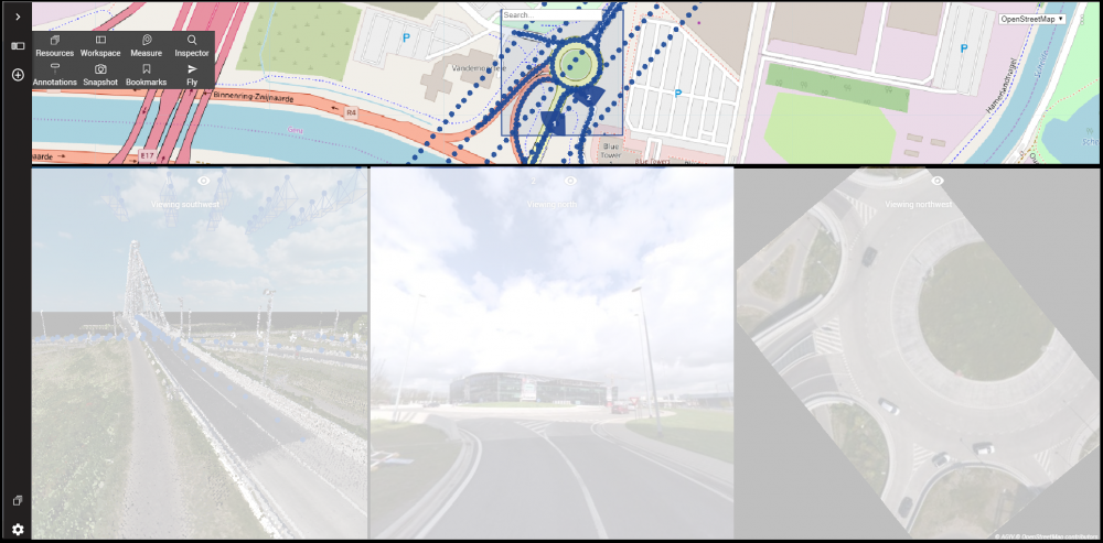
The Reference View is a 2D view on which a 2D basemap from the user's choice can be overlaid with 2D vector resources and footprints and field of views of 3D resources.
The reference basemap
Via the Basemap Selection Menu it is possible to change the 2D basemap of the Reference View.
Display of footprints and field of views
How the footprints and field of views are displayed on the Reference View depends on the data type of the available resources.
Mobile Mapping and Planar Photo Positions
- Blue dots: Represent the photo positions or recording locations. These are visible up to a map scale of 1/1500.
- Blue pie-slices: Heading and field of view of a Mobile Mapping View. The number on the pie-slice corresponds to the number of the view.
Photo positions can be turned on/off from the Resources Sidebar
Check the page “MM View > Navigate, Open and Close Views” for an overview of the navigate and open view functions.
Oblique Footprints
- Blue quadrangle: the border of the footprint of the active photo.
- Green cross: Center of Oblique View.
- Red cross: Location of the cursor on Oblique View.
Footprints can be turned on/off from the Resources sidebar.
Vector overlays
Vector layers are by default not displayed in the Reference View. This can be changed in the Settings menu.
How vector overlays are displayed is dependent of the legend of the vector layer. This can be set in the Resources sidebar. Note that a vector dataset may not be visible due to scale limit limitations.