For documentation on the current version, please check Knowledge Base.
3D Mapping Cloud Upload
This page describes the desktop extension “3D Mapping Cloud Upload”.
Content Manager
![]() Main Toolbar > Extensions > 3D Mapping Cloud Upload
Main Toolbar > Extensions > 3D Mapping Cloud Upload
Cloud Upload Tool
![]() Top Toolbar > Upload
Top Toolbar > Upload
Concepts
3D Mapping Cloud
Orbit GT's 3D Mapping Cloud platform is used for streaming and sharing unlimited size of mapping resources.
The desktop extension “3D Mapping Cloud” makes it possible to upload and delete resources from your 3D Mapping Cloud account.
Prepare Resources to upload
The 3D Mapping Cloud supports native Orbit resources only : mapping resources, image, point cloud and vector resources.
See Concepts of Mobile Mapping and UAS data in Orbit, Supported Geodata Resources.
Runs and resources must be prepared properly prior to upload.
Images part of Mapping Resource must be optimized into processed images to get the run ready for upload. Original images aren't uploaded.
See Optimize Imagery of Mapping Run\Oblique Project.
Sidebar
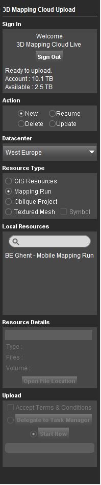
Sign In
Sign with your 3D Mapping Cloud login.
Users of an active 3D Mapping Cloud account and having the administrator role are able to sign in and manage resources.
None administrators or users having a Free Trial Plan cannot upload data.
To create your account, go to https://3dmapping.cloud.
Action
Select the action :
- New : Upload a resource.
- Delete : Delete an uploaded resource.
- Resume : Resume a paused or cancelled resource upload.
- Update : Update a resource already uploaded. - A run that has been modified cannot be updated.
Datacenter
Datacenter information will be available only when uploading a new resource. This information is linked to the 3DMC account and can be modified upon request. It has no influence in the geographic location of the resources.
Resource Type
Select the resource :
- GIS Resources : Ready to upload GIS Resources as available in the current Dataset List.
- Mapping Run : Ready to upload Mapping Runs as available in the Catalog.
- Oblique Project: Ready to upload Oblique Projects as available in the Catalog.
- Textured Mesh: Ready to upload Textured Mesh datasets when available on your server or locally on your computer. Check 'symbol' if it should be used as a 3D Model in your publication.
Local Resources
A list of the available resources. Note that only Cloud ready Mobile Mapping and Oblique Projects resources will be listened and all the reference data must be in Orbit format.
Resource Details
Review the metadata of the selected resource and, optionally, enter a new name of the resource to be used by the 3D Mapping Cloud.
Upload, Delete, Resume, Update
Start the action immediately or delegate to the Task Manager.
Tab
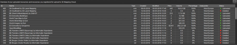
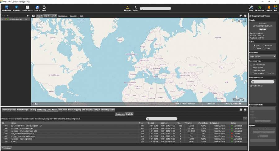
The “3D Mapping Cloud Upload” tab gives an overview of all uploaded resources and displays the status of ongoing uploads.