For documentation on the current version, please check Knowledge Base.
EOS Console > Publishers
This page describes the EOS Console tab “Publishers tab for both “Mobile Mapping” and “Oblique”.
The homepage for all documentation about the Publishers, see Orbit MM Publisher or Orbit Oblique Publisher.
![]() EOS Console > Publishers
EOS Console > Publishers
Concepts
- The concepts and design of Mobile Mapping and Oblique Publications are similar, differences are documented if applicable.
- A Publication is a well defined combination of Reference Data (Basemaps and Vector Overlays) and Mobile Mapping or Oblique resources.
- Access to a Publication is set via its included Mobile Mapping or Oblique Projects.
- Basic concepts about Mobile Mapping Resources (Runs, Projects, Categories and Publications), see Concepts about Mobile Mapping data in Orbit.
Publications
At the left hand side all publications are listed.
- Add, remove or copy a publication using the according buttons at the bottom of this list.
- Set all configurations for the the selected publication using the 4 tabs at the right hand side.
- Main : Set publication name, crs, login and publish the publication.
- MM Data / Oblique Data : Set mobile mapping / oblique projects, categories and some data related settings and preferences.
- Viewer : Set all publication related settings. Settings cannot be changed or updated by the publication user.
- Preferences : Set all publication related preferences. Preferences can be updated by the user after opening the publication.
Main
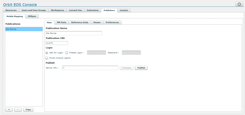
Publication Name
What's is a name, give a clear name for the publication :
- the name should be unique, mobile mapping and oblique publication cannot share the same name.
- the publication name is part of the publication url, consequently it is advised to use lower case characters only, avoid spaces and special characters.
Publiation CRS
Enter the publication's coordinate system via its EPSG code.
The publication CRS is used to display :
- Map view
- Coordinate measurement results
A publication CRS is required :
- If no publication CRS is entered the Vector Overlay datasetlist Workspace CRS (see Reference Data below) will be used as publication CRS.
- If no publication CRS is entered and no Vector Overlay datasetlist is set, it will not be possible to open the publication.
The use of a combined coordinate system including a vertical CRS is supported, enter <EPSG code of horizontal CRS>+<EPSG code of vertical CRS>.
More information about coordinate systems : Coordinate Reference Systems.
Login
Only known Orbit user can access a publication. It is not possible to load a publication anonymously. Users are managed via the EOS Console's “Users and User Groups” tab : EOS Console > Users and User Groups
A user must have permission to access at least one mobile mapping or oblique project included in the publication to open the publication. But even if a user is able to open the publication, only reference data and data from projects for which permissions are granted will be visible.
Permissions on projects are set via the EOS Console's “Extensions” tab : EOS Console > Extensions
- Ask for login : Protect your publication, when loading the publication it will be required to enter username and password.
- Preset Login : Preset user credentials to auto login when someone is opening the publication.
- Force unique logins : Restrict publication access to single users to protect a publication to be used simultaneously on multiple hardware using the same login (user credentials). If access to a publication is refused due to this unique login setting the following message is displayed : “Failed to login due to license constraints on server.”
Publish
A publication is accessible via a publication url. This publication url looks like : http://<server url>/publications/<publication name>/index.html
Server URL
A Web server is embedded in the Orbit Publisher however redirecting via a reverse proxy is advised for online use.
More information about this, see Requirements for Orbit Publisher.
The default embedded Web server uses http and port 1111.
The server url looks like http://<server id>:1111/. The Server id can be its (a) DNS name or (b) public ip. Use two forward slashes "//" to reuse the server url as entered in the web browser address bar to access the publication.
Publish
A single click on the “Publish” button will deploy the selected publication using all available template html pages.
Orbit provides the default index.html web page, customized pages can be added here : <Orbit installation directory>/server/program/services/publisher/publication_template
If the publication name, login settings or server url are updated, it is required re-publish the publication to take advantage of the updated settings. Depending the browser settings it may be required to remove cached images and files to force the viewing client to request the updated html page.
MM Data / Oblique Data
Manage the mobile mapping or oblique resources and related settings & user preferences.
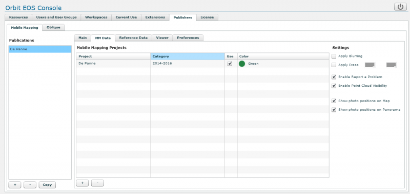
Projects
- Add or remove a Project using the according buttons at the bottom of this list (setting).
- Enter a Category name for added projects (setting).
The category name is visible for users. All Projects with the same Category will be grouped and visible as one entry for the user. Orbit will automatically sync the project Use and Color for all Projects of grouped by their Category. If no category name is set, the project will be available at all time. - Set the default Use of a Project and by extension the Category to which it belongs (preference).
Only photos and according metadata from “used projects” can be requested and displayed. - Set the Category Color used to display photo position, coverage, field of view or footprints (setting).
Settings
Some settings related to Mobile Mapping content. These settings are not available for Oblique Publications.
- Apply Blurring
- Apply Erase : blur and/or erase defined areas. The erase above horizon (1) and below horizon (2) colors can be adjusted to your preference.
- Enable Report a Problem
- Enable Point cloud Visibility : Add the possibility to display the point cloud overlay on panoramas.
The point cloud is displayed with a fix legend, based on distance to the panorama position. If required this single system legend setting can be adjusted via the point cloud legend configuration file :
<Orbit_installation directory>/server/program/wwwroot/publications/point_cloud_panorama_legend.ini
The publication point cloud display requires additional processing power. Pay attention to the server's memory and CPU consumption. - Show photo positions on Map / Panorama : Set the default visibility of photo positions and coverages on map and panoramas (preference).
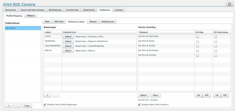
Reference Data
Manage the publication's basemaps and vector overlays and some related settings & user preferences.
Workapse datsetlist
A supported vector or image resource or any combination of supported resources can be added as reference data to a publication using a Workspace Datasetlist only. All included datasets will be used, with respect to their datasetlist order, resource display name, legend and scale limits.
To create and manage Workspaces see EOS Console > Workspaces.
Dataset legend
The resource Orbit legend will be used to display the vector overlays on map and panoramas.
There are no legend limitations on the map component for both basemaps and vector overlays. Only the following Orbit legend settings (no classifications) are taken into account for vector overlays on panoramas :
- From Basic Appearance :
- Area Settings : fill color, fill transparency, outline color, outline width, outline transparency
- Line Settings : color, width (points on screen), transparency
- Symbol Settings : library, name, visibility, size (points on screen only), size draw icons 1:1, transparency, fill color, outline color
- From Labels :
- Label Settings : size, hotspot, type (text, box, box rounded, callout, callout rounded), text color, box fill color, box outline color
Basemaps
- Add and remove a datasetlist as basemap using the according buttons at the bottom of this list.
- Maximum 6 basemaps can be added.
- The first listed basemap will be the default on start-up
- Select a datasetlist using the according button.
- Rename the basemap label with a click on its
- Enable client WMS basemaps : allow the user to add temporary additional WMS layers as publication basemaps.However, most of the times the connection will not be possible in the webclient due to Cross-domain restrictions on web servers
Vector Overlay
Vector overlays are available for mobile mapping publications only.
Only vector resources should be overlayed on panorama images. It is a bad idea to display image resources on panorama images.
- Select and add or clear the datasetlist
- Only one datasetlist can be added a
- The listed datasets and their order cannot be updated here, this is managed via the workspace.
- Set the default visibility of each resource on map and panorama (preference)
- Enable client WFS overlays : allow the user to add additional temporary WFS layers as publication vector overlays.
The dataset name will be empty (blank) in the publication's vector overlay window if :
- no dataset crs has been set
- the dataset fromat is not supported as vector overlay (e.g. image or raster resources)
Viewer
Manage the publication's settings.
Settings cannot not be changed or updated by the publication user. Preferences (see below) can be updated by the user after opening the publication.
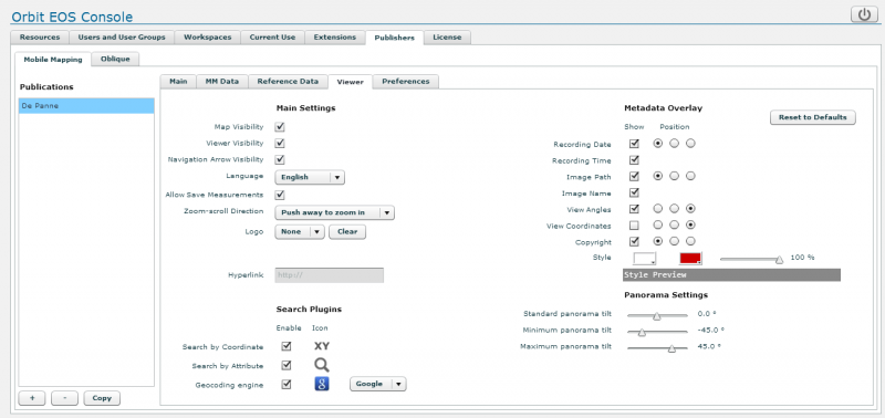
Logo
Add an available logo on top of each viewer component and set its hyperlink url.
All *.jpg and *.png image files that reside in following server service directory will be available from the logo drop down :
<Orbit installation directory>/server/program/services/publisher/publication_logos/
Logo's are displayed by 100×30 pixels and will be re-sized (ratio respected) if needed.
Search Plugins
Add a geocoding engine to the publication :
- The plugin will be available as default search engine via the map component search box.
- Only one geocoding plugin can be added to the publication.
Geocoding services are varied, and implementation cannot be standardized. Therefore Orbit delegate the implementation of a geocoding service to JavaScript, which can be added on the fly and edited, adapted, debugged by you.
Geocoding plugins are stored on the server : <Orbit installation directory>/server/program/services/ext_publisher/publication_geocode_plugins
More information about creating your geocoding plugin, see Notes on Geocoding Plugins
Preferences
Manage the publication's user preferences.
Preferences can be updated by the user after opening the publication. Settings (see “Viewer” above) cannot not be changed or updated by the publication user.

Startup Coordinate
Fall back startup position and orientation, used if a publication is opened without specifying a startup coordinate or PhotoId.
- X,Y : startup coordinates.
If coordinate X=0 and Y=0 is entered, the closest image to the center of the first run, of the first project of the publication will be searched. - CRS : EPSG code of entered X,Y startup coordinates.
If not set the Publication CRS (see above “Main”) will be applied on the entered coordinates. - Scale : Map scale at startup.
The units of a scale (meter, feet, degree) are defined by the Publication CRS. A geographical publication crs (e.g. WGS84, EPSG 4326) may require to enter a decimal value like 1/0.1 to get the appropriated startup map view.
Settings
Default user settings for the publication. They can be adjusted by the user in the settings panel of the viewer.