For documentation on the current version, please check Knowledge Base.
Measurements with a single click using Point Cloud
This page describes the concept and some related settings of measuring using point cloud.
More information related to mobile mapping measurements on Orbit Desktop and Orbit WebClient :
- Desktop : Measurements on Mobile Mapping Views
- WebClient : Measure on Mobile Mapping Photo Views
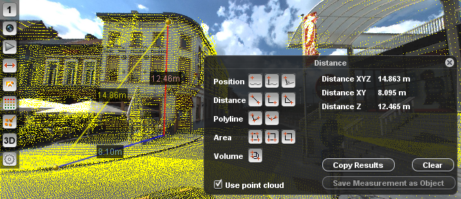
Flag the check box “Use Point Cloud” on the Measure window.
Single Click
The use of a point cloud simplifies a mobile mapping measurement. A coordinate measurement can be done with a single click in a single view. Much faster compared to measurements via triangulation, but some experience and basic knowledge about point clouds is advised.
Gaps
Keep in mind that transparent objects (e.g. glass) may not reflect the point cloud laser and are consequently “invisible objects” in point cloud. Consider also gaps “behind objects” as seen from the scanning position
Ghosts
Moving objects may appear at a different position in the point cloud compared to their precnese in the imagery due the difference in time of recording.
A correct setting and interpretation of the Point Cloud Hover and its representation on the Map 2D can help to avoid these 'Ghost measurements“.
If a time stamp is available for both imagery and point cloud it is possible to restrict the point cloud display via the according Display Restriction Time Setting, see above “Measurements and 3D Hover for Mobile Mapping View”.
Point Cloud File Access or Point Cloud Service
A point cloud can be available via direct file access or through a point cloud service.
If the desktop client has direct file access to the Orbit Run containing the Orbit Point Cloud files (*.opc) coordinate measurements using point cloud will be calculated according the 3D Hover setting, see Preferences of 3D Hover.
When using a point cloud service, coordinate measurements will be requested from the point cloud service. The client will only display the coordinate measure result as calculated and returned by the service. The 3D Hover and its according settings are not available when using a point cloud service. However the Orbit Publisher point cloud service do allow to overlay the point cloud on image.
The Orbit Desktop Client supports both, point cloud file access and service. The Orbit WebClient supports point cloud service service only.
3D Hover for Mobile Mapping View
The Orbit Mobile Mapping Desktop Clients are using Orbit's generic 3D Hover concept, see above “Preference of 3D Hover”.
One extra functionality is added. On using the Mobile Mapping Image View the point cloud doesn't need to be set visible on the image to be used by the 3D Hover. The Point Cloud Legend and Restriction Settings on Mobile Mapping Views are taken into account at all time, even if the point cloud is set to be invisible.