This is documentation of an archived release.
For documentation on the current version, please check Knowledge Base.
For documentation on the current version, please check Knowledge Base.
Create New Dataset
To create a new dataset, the new dataset wizard has to be used.

- At least one dataset has to be open to determine any reference to a coordinate system or a coordinate system has to be assigned to the dataset (??)
- Only one model will be defined in this new dataset. After finishing the wizard, it is possible to modify the dataset structure and properties.
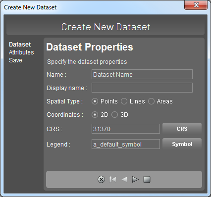
New Dataset Wizard
- Enter a name for the new dataset. This name will be used in the dataset list.

- Select the spatial data type: point, line or area.
-
- Click
 to add an additional attribute, select an attribute in the list and click
  to remove an attribute.
 - If there is no attribute name entered, the attribute will not be added.
- After entering all attributes and specifying their data types, finish the wizard and save the new dataset by clicking
 .
.

- Specify the location and enter a name for the dataset.

- The new dataset will appear on top of the dataset list.
- It is now possible to modify the dataset structure (add a model, add an attribute set, specify rules, etc.)
- To create and add objects for this new dataset, use the edit tools sidebar.

Last modified:: 2019/03/25 11:36