For documentation on the current version, please check Knowledge Base.
Browser based Mobile Mapping Viewer
The Orbit Mobile Mapping Publisher makes it possible to publish Mobile Mapping content within a browser over the internet or in a local network.
This page describes only the use of an Orbit publication within a browser.
For all other use, management or requirements review : Orbit MM Publisher
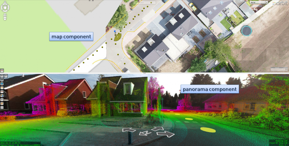
| Map component | |
|---|---|
| Map Component | Change basemaps, navigation on the map and open a new panorama by searching by geocoding, XY or objects on the map. |
| Navigation on panorama images | Navigate on the panorama images and open a new image by searching or clicking a location. |
| Measure on map | Measure a point, distance, angle or area on the map. |
| Panorama component | |
|---|---|
| Panorama Component | Generic overview of the functions of the panorama component. |
| Navigation on panorama images | Navigate on the panorama images and open a new image by searching or clicking a location. |
| Measure in panorama images | Measure a point, distance, area or volume on the panorama images. |
| Image Toolbar | All info on the toolbar of the panorama component and its functions. |
Open a Publication
A Publication can be opened via a direct url or embedded, as a part of a webpage. A url is case sensitive. Pay attention to perfect spelling.
Depending the configuration of your server the direct publication url will look like :
http://<server name>:<port>/publications/<publication name>/<page>.html
A default Orbit configuration provides 3 html pages (/<page>.html) to open your publication :
- \index.html : The publication will be opened with a Map and Panorama component
- \panorama.html : Only the Panorama component will be opened
- \map.html : Only the Map component will be opened.
A publication is loaded with a default start-up location and map scale. These are defined by the administrator.
Contact your service provider to know more about your publications and their direct url's.
Open Panorama at X,Y
Open the publication on a specific position defined by XY coordinates :
http://<server name>:<port>/publications/<publication name>/panorama.html?x=<X-coordinate>&y=<Y-coordinate>&crs=<EPSG code>
- <X-coordinate> : value for X with . as decimal separator.
- <Y-coordinate> : value for Y with . as decimal separator.
- <EPSG code> : optional crs EPSG code of the given x,y coordinates. If no crs is set the publication crs will be used.
Open Panorama with PhotoID
Open the publication with a specific position defined by a photo ID :
http://<server name>:<port>/publications/<publication name>/panorama.html?photoId=<Orbit photoId>
- <Orbit photoId> : The photoId of the panorama image is displayed in the lower left corner of each image view.
The Orbit photoId is a composed string of [project]/[run]/[image]. Both the complete string as the [image] tag only can be used as Orbit photoId.
Note if the [image] tag is not an unique identifier within the opened publication, the first image result will be returned.