Table of Contents
Orbit Vector File
The Orbit Vector File (*.ovf) is Orbit's native vector file storage format.
An OVF stores object geometry and attribute information.
Structure
An Orbit Vector File has extended data structure capabilities compared to an Esri Shapefile
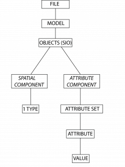
- A Dataset has one or more Models.
- A Model has one Spatial Component and one Attribute Component.
- The Spatial Component has one Object Type (Points, Lines or Areas) and one Coordinate Type (2D or 3D).
- The Attribute Component has zero, one or more Attribute Sets.
- An Attribute Set groups zero, one or more Attributes.
- An Attribute has one Attribute Data Type (Double, Float, Integer, String or Boolean).
- A Model has zero, one or more Objects.
- An Object has one or more Parts : Spatial Component
- A Point Object Part has one Coordinate or Vertex,
a Line Object Part two or more Vertices,
an Area Object Part three or more Vertices. - An Object has for each Attribute Set zero, one or more Sets of Attribute Values : Attribute Component
Structure compared to Esri Shapefile

Each vector resource has the same building blocks, but conditions and interpretation may differ.
A Shapefile must have exactly one model, exactly one attribute set, at least one attribute and exactly one set of attribute values. Also GPX, KML and KMZ resource do have a strict dataset structure.
If the dataset structure doesn't match one of the resource structure conditions an error will occur at export or save dataset.
A shapefile has the attribute names length limited to ten characters, a longer name will be trimmed. As a result, if creating or exporting a shapefile in Orbit, attribute names will be trimmed to ten characters. Any rules associated with that attribute will be affected.
Reasons to use
The OVF is optimized for fast editing of vector data in Orbit. The format is platform independent and its structure capabilities reduce the number of files and simplify data management.
For example a single dataset (road markings) having objects (areas, lines and points) that belong to each other but that do have a different geometry.
Create and Update
- Create & Open Resource, see Datasets & Dataset Lists.
- View & Edit Dataset Structure, see Dataset Structure.
- Add, Edit & Remove Objects, see 2D Edits.
- View & Edit attributes, see Object Inspector.
Legend and Georeference
The resource can be accompanied by an Orbit Legend File and Orbit Resource Descriptor.