Table of Contents
What's New Version 22.4
What's New Presentation
The recorded What's New presentation can be watched on-demand here.
3DM Desktop Core
New Features and Enhancements
- Catalog Usability
- All mapping resources (aerial/mobile/oblique) can be listed in one catalog table.
- Sort on integer columns now uses the absolute integer value.
- Right-click on a catalog resource directly opens the context menu. This avoids the extra click to select the resource.
- The web-readiness check for point vector datasets checks if there is an Orbit Symbol Library (osl) file next to the vector file. If the osl file is not there and the user has write permissions, the correct osl file will be copied next to the vector file.
- The catalog preferences have been updated to match the references resources.
- Increase Loaded PWCS Projects
The limit of loading 100 PWCS projects has been removed in the ContextShare extension. - Upload Reality Data to Asset ID
The ContextShare upload extensions also list assets to upload resources to. - Copy Azure Blob Container SAS URL of PWCS Resources
The ContextShare tab resources have a context menu where the read or write blob container SAS URL can be copied. - Procedure to Optimize Annotations
The step 'Annotations' within the Optimize Imagery procedure can optimize the 2D objects and 2D segmentations annotations next to the optimized images. The 2D segmentation omi files can be overlayed on the optimized images. - Copy Osl File Next to Mapping Resource Photo Positions
At opening a mapping resource, the Orbit Symbol Library (osl) file for photo position file is copied next to every locations.ovt file. - Display Photo Positions on Map 3D(GL)
The photo positions of mapping resources are displayed in Map GL. - Omi as Source Format at Optimize Image Resource
- Set Custom Jpeg Quality at Optimize Image Resource
- List Pointcloud Classes in Datasetlist
After writing an Orbit Point Cloud and import classification, the classes are written away in the ord file next to the OPC. The classes are then listed in the dataset list and can be enabled/disabled. Existing OPC files with classification will have to be re-optimized. - Point Cloud Selection
- Created and displayed on the mapping tab and slice view
- Generate Point Cloud Selection Files From Classification
The point cloud selection tool can create an orbit point cloud selection file (ops) for every class within the selected point cloud. - New Pointcloud Format
- The SLPK file can be rendered on Map GL and optimized into an orbit point cloud.
- The PLY file can be optimized into an orbit point cloud.
- The i3s file can be rendered on Map GL.
- New Mesh Format
- The SLPK file can be rendered on Map GL and optimized into a web-ready scalable mesh.
- The i3s file can be rendered on Map GL.
- Set Target Directory and Name at Optimize Mesh
A subdirectory with the target name is created in the target directory. All mesh files are written away in the subdirectory. - Point Cloud View Depth on Map 3D
The view depth slider for point cloud datasets has been added to the point cloud legend editor in Map 3D. - Processed Imagery Not Closed Properly
A closed processed image was locked and could not be deleted on disk. - Tool 'Create Centerline'
This new tool requires two selected lines from which the centerline is created. The resulting line can be saved to an existing vector dataset or a new dataset can be created. - Tool 'Create TIN'
- Select Objects on Map 3D via Keystrokes
The keystroke 'orbitgis.toolbar.select.mnemonic' can be used to select objects on both Map 2D and 3D. - Display OrbitCameraDescription at Import Run
At import run where camera calibration parameters are entered, the OrbitCameraDescription is displayed underneath the camera name. - Allow '(' and ')' for Resource Upload to 3DM Cloud and ContextShare
- Moved from Beta to Live: Optimize Mesh
Usabilities
- Disabled Convert/Optimize Options
The target options in the convert and optimize tool are disabled when no source file(s) has been selected. - Clear Formula Search Field after Add/Set Record
The formula search field at creating vector data attributes, is cleared when the formula attribute has been added or set.
Layout
- Increased Tools Sidebar Width
Bug Fixes
- Convert 2D vector data to 3D failed when using point cloud references and full area object.
- The startFrom and SkipX was not properly used when starting from a row not equal to the first row.
- Incorrect height tiles of point cloud resources were loaded on Map 2D.
3DM Content Manager
The 3DM Content Manager includes all 3DM Core improvements.
New Features and Enhancements
- Process Data: Create Template From Run
A template can be created from the opened mapping resource via the Process Data procedure. - Tool to Create Panorama from Point Cloud
A new batch file has been added to the bin_tools folder to create panorama imagery from the mapping run point cloud and locations.ovt. - Script to Convert Image Data
A new batch script has been added to the bin_scripts folder to convert the image resource storage format for all image files in a specified directory. Read from and write to any supported storage format.
3DM Import And Upload Tool
New Features and Enhancements
- Remove Obsolete Items from Catalog Context Menu
The items in the resource context menu of the catalog that are not available in the product, have been removed.
3DM Feature Extraction
The 3DM Feature Extraction includes all 3DM Core improvements.
New Features and Enhancements
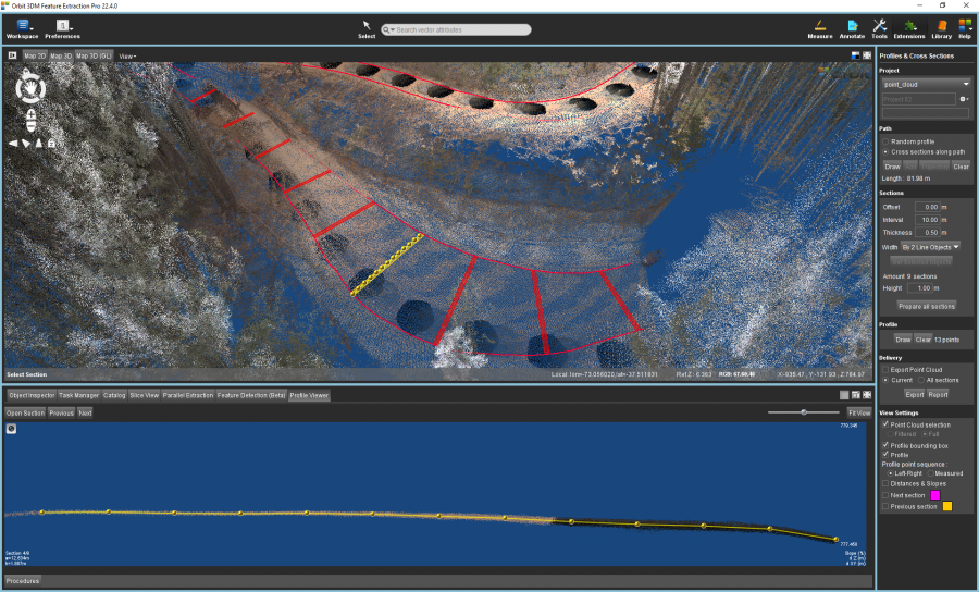
- Profiles & Cross Sections
- Automatic Creation of Profiles
At preparing all sections and/or opening a section, the profile in the section is automatically created based on the points of the point cloud. The profile can be edited via the Draw button. - Advanced Creation of Sections
There are 3 new options to define the width of sections in the Profiles & Cross Sections extension: Fixed left/right offset, by 2 line objects and by area object.
- Add/Remove/Intersect Measurement Point Cloud Selection to Active Point Cloud Selection
Add, remove or intersect the point cloud selection from the measurement (if available) to the active point cloud selection. - Remove Obsolete Items from Catalog Context Menu
The items in the resource context menu of the catalog that are not available in the product, have been removed. - Remove Create Snapshot from Extension
The traffic sign detection no longer includes the option to create snapshots. Creating snapshots can be done via the dedicated Asset Inventory procedure. - Moved from Beta to Live: ContextInsights extension
Usabilities
- Inactive Measurements Based on Measure Preference
The measurements that cannot be used for the selected measurement technique, have been disabled.
Bug Fixes
- Export/Edit theme in asset inventory was not working.
3DM Viewer
The 3DM Viewer includes all 3DM Core improvements.
New Features and Enhancements
- Apply Resource Footprint Transparency on All Views
The resource footprint transparency is now also applied on the reference view and 3D view. - Drag and Drop
- Annotation File
Drag and drop of the o3a will replace the current annotations by the one from the o3a file. - Measurement File
Drag and drop of the o3m will replace the current measurements by the one from the o3m file. - KML File Display
The 3DM viewer uses a default symbol library and legend when adding a KML to the 3DM Viewer as resource. Removing the need to have an osl and olg file next to the KML file.
- Snapshot of Entire Workspace
Snapshots can also be created from the entire workspaces, including all the views instead of just one. - Point Cloud Time Slider
The viewer setting 'Maximum Time Offset Point cloud' sets the time offset of the rendered points of the point cloud compared to the timestamp of the opened image. This is only applicable to point clouds that are overlayed on an image. - Removed Viewer Setting for Clickable Photo Positions
The photo positions are always clickable and cannot be toggled off. - Read Publication Logo Transparency
The transparency of the publication logo is correctly applied in the 3DM Viewer. The logo is also not displayed as a circle anymore. Hovering over the publication logo will highlight the logo. - Hide Publication Sidebar
The publication sidebar can be made completely hidden via the publication specs & tags. - Support Samsung Internet Browser
- Completed Listed of Quick Viewer Settings
Layout
- Set Viewer Style
- Light versus Dark Mode
The generic style of the viewer can be set to light and dark. Following the system settings will adjust the mode to the one of the machine. - Highlight Color
One highlight color can be chosen from multiple predefined colors.
- Unified Viewer Sidebar, Catalog and Settings
Multiple styling adjustments have been done to align the style of the sidebars, viewer catalog and settings.
Bug fixes
- Switching from a 3D View to a spherical view always opened a north-oriented image.
- The viewer settings for the view action menu were empty when launching a publication and were available for non-admin users.
- A measurement was saved twice when autosave measurements was enabled.
3DM Viewer SDK
The 3DM Viewer SDK includes all 3DM Viewer improvements.
New Features and Enhancements
- Function to Open Session
The new function 'openSession' makes it possible to re-activate a session via the sdk.
Bug Fixes
- The fullscreen button didn't work as expected within Shadow DOM.
- When startup_skip_views is used and no oblique image could be opened, the pixel size stored in the workspace is used. Resulting in having the same oblique zoom level as the initial publication.
3DM Publisher
The 3DM Publisher includes the 3DM core and 3DM Viewer improvements.
New Features and Enhancements
- Reset Password for Users
The viewer login screen has the option to reset the password of a user. - Import Special Characters at Import Multiple Users and Resources
The limitation on number of bytes has been removed, enabling the support of special characters.
Bug Fixes
- Restarting the publisher after an update is no longer required to have the correct minimum and maximum sessions for publications.
- The usage now loads the latest/most recent records from the usage table and not the oldest ones.
3DM Cloud
The 3DM Cloud includes the 3DM core and 3DM Viewer improvements.
New Features and Enhancements
- ContextShare Resources:
- Footprints displayed on the reference view have the correct label (no longer 'null').
- Unlink resources listed in My Catalog and Company Catalog.
- Remove limitation of loading 100 PWCS projects.
- Ortho resources are detected as base maps in the 3DM Viewer.
- List of Bookmarks
Bookmarks are listed in the Cloud console and can be directly opened via the context menu or token. - Set Default Viewer Styling in Named User Preferences
The mode and highlight color can be set in My Profile preferences. - Correct Display of ContextShare Resources Timestamp
Bug Fixes
- The scroll bar was not displayed in the guest users list.
- The owner of the Cloud organization was not indicated in the user list.
- The administrator role was not correctly recognized in the user list.
- Tags of publications, resource groups and annotation objects were not added to the tags occurence number.