Dataset Properties Inspect
The Storage Properties panel contains information about the username and projection of the dataset. It also manages the global scale limits.
![]()
Right-Click on the dataset in the Datasets & Dataset Lists > Context menu > Dataset Properties > Inspect
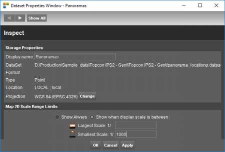
| Storage Properties | |
|---|---|
| Username | This is the name of the dataset as displayed in the Context Menu. By entering a new name the username can be changed easily. |
| DataSet | Shows the location of the dataset on the computer or the Registry Name of the dataset defined by the EOS-Console. |
| Format | Shows the format of the dataset. (ovf, shp, omi,…) |
| Location | Shows the locationtype of the dataset: Local or EOS. |
| Projection | Displays the Coordinate Reference System of the dataset. If no CRS is set the projection will be “undefined”. Click the “Change” button to set or modify the dataset CRS. To re-project the dataset to anorher CRS, the Convert tool must be used More information about the dataset CRS, read Coordinate Reference Systems. |
Scale Range Limits
Restrict the display of the entire dataset on Map 2D to a well defined scale range. Outside scale ranges the dataset won't be displayed.
To set different scale range limits for each dataset model or spatial (objects) and layout (labels, pie charts) components, see Dataset Legend : General Settings
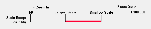
The dataset won't be displayed if :
- the map scale is larger (zoom in more) than the “Largest Scale”
- the map scale is smaller (zoom out more) than the “Smallest Scale”
Remarks on scale range limits :
- Scale ranges are useful to optimize performance of lading vector data, to avoid loading vector details that can't be distinguished at small scales.
- Scale ranges are not applied on Map 3D.
- Scale range limits are verified against the Map scale as displayed in the map status bar. Note map scale units depend the map coordinate reference system.
- The dataset user name in the dataset list will be displayed italic to indicate the dataset is not displayed due to dataset scale range limitations, see Dataset Operations and Indicators in DataSet List.