Orbit Image File
OIF stands for Orbit Image File and is a native file format developed by Orbit GT for storing images. OIF does not support multiresolution.
Structure
OIF can manage single-band raster images, black & white images, and standard RGB or 3-band images.
Reasons to use
- OIF is native to Orbit GT and stores image data in binary format (serialization) and optimized for fast reading and visualization.
- OIF is also neutral to images types and platform independent and can be shared among Windows, Linux and Mac.
Create and Update
An OIF can be created via the Tools:
- Convert Data : Convert one on one, one Image to one OIF (or other image storage file format)
Options and Compression
OIF uses either lossy or lossless compression: for every individual tile OIF determinates the most effective compression method.
When creating an OIF, flowing options are available to define storage and compression.
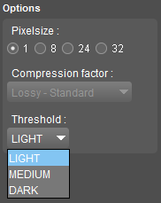
Pixelsize
Define the number of bits (1, 8, 24 or 32) to be used to store one pixel of (raster or image) resource 1)
| Bits/Sample | Samples/Pixel | Bits/Pixel | Image type |
| 1 | 1 | 1 | Monochrome black-white |
| 8 | 1 | 8 | Grayscale |
| 8 | 3 | 24 | RGB (red green blue) |
| 8 | 4 | 32 | ARGB (alpha/transparency RGB) |
Pixelsize 1
A pixel can hold one sample with 2 possible values 0 (black) or 1 (white).
When using pixelsize 1, it will be possible to set a threshold : Light, Medium or Dark.
Applying a threshold is a method to simplify an image to sets of pixels with corresponding values. The result is an image containing contiguous regions of the same value. This technique makes it easier to apply analysis.
- Light will favor light color values.
- Dark will aggregate dark color values.
Pixelsize 24
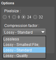
A pixel can hold 3 samples with a value between 0 .. 255.
Using pixelsize 24 enables extra quality parameters. :
- Lossless “fully recoverable”, no compression
- Lossy “with losses to quality”
- Smallest file
- Standard
- Quality
Lossy meaning “with losses to quality”. Approximate sample values will be stored with sample value compression rate 5:1 up to 20:1
Examples .jpg, .ecw, .sid
Lossless always returns the original data. Lossless meaning “fully recoverable”. The exact sample values will be stored.
Examples : .gif, .png, .bmp
It is advised to save images with a wide variety of colors (photos) with lossy compression (jpg).
Images with a limited variety (computer graphics, icons) should be saved lossless (png).
Pixelsize 8 and 32 have no extra format options.
Legend and Georeference
Optionally an OMI can be accompanied by an Orbit Legend and Orbit Resource Descriptor in Orbit. OIF contains georeference information in its header.