Table of Contents
Web-based Resources
This portal page provides access to all documentation related to support for web-based resources.
Orbit supports Web Map Services, Web Map Tile Services, Web Feature Services, and Tile Map Services.
Web Map and Web Feature Services
Web Map Service (WMS), Web Map Tile Services (WMTS), and Web Feature Service (WFS) are the standard protocols of the Open Geospatial Consortium for serving, viewing, or editing georeferenced map images and geographical features over the internet or Intranet using platform-independent calls.
More information:
Supported Versions
Orbit supports Web services as described by the OGC:
Supported versions
- WMS versions 1.1.0, 1.1.1 and 1.3.0
- WMTS version 1.0.0
- WFS versions 1.1.0, 2.0.0
Remarks
- View only (WFS)
WFS support is limited to view only for both spatial and attribute components.
Editing or updating WFS features and styling is not supported.
Via a file-based connection an Orbit legend can be defined. - Supported object types (WFS)
Orbit's engine supports only the vector-based variant of the following WFS Object types:
Point, MultiPoint, LineString, MultiLineString, Curve, MultiCurve, Surface, MultiSurface, Polygon, MultiPolygon - Internal resource name
No point “.” characters allowed in web resource internal name.
Check the internal name via Dataset Properties > General > Dataset : <Orbit web service name>.<internal web service resource name> .
If the internal name contains one or more points then the resource cannot be used.
Orbit Connection to WebService
There are 2 options to establish a connection to a WebService:
File-based WebService Configuration
Establish the connection using an Orbit configuration file to a well-defined WebService Layer.
This file-based configuration is supported by all products and today's recommended solution.
More information, see Orbit Web service file.
WebService CRS and Orbit Map CRS
The Orbit Map CRS will be used to define the Bounding Box of the GetMap WebService map request. To avoid issues related to coordinate transformations, it is advised to set the Orbit Map CRS to a WebService supported coordinate system.
More information about Orbit Map and Dataset CRS, see Coordinate Reference Systems.
WebService in Orbit 3DM Viewer
Special attention is required to use WMS and WMTS layers in the Orbit 3DM Viewer.
More information, see Tiled Map Configuration for Web Map Services.
Tiled Map Service
Tiled Map Services (TMS) are made popular by Google and OpenStreetMap.
More information, see Tiled web map.
Supported Versions
The common standards and custom pyramid-based tile services are supported by Orbit.
Orbit Connection to Tiled Map Service
There is only 1 option to establish a connection to a Tiled Map Service.
File-based Tiled Map Configuration
Establish the connection using an Orbit configuration file to a well-defined Tiled Map Layer, see Orbit Tile Map Service file.
IT Troubleshooting
This paragraph documents common IT issues related to loading web resources.
SSL Trusted Authority
When loading web resources via a secured HTTPS connection, the website's Security Certificate must be available to the Java Runtime Engine used by Orbit Desktop or supported by .
More information, see SSL Certificate for Java Keystore.
SSL Mixed Content
Network connectivity
To use a Web-based resource a successful network connection to the providing server/service is required.
If no connection could be established, obviously Orbit will not be able to load the resource. Review the documentation below on how to check the connection from the local network to the web service.
If a network connection is successful, but Orbit can't load resources, most probably the Orbit application is not allowed to get online/network access due to an internal internet security application (e.g. aXsGUARD Gatekeeper from Vasco). The network and/or local computer administrator need to adjust your security settings or configure a proxy to be used by Orbit :
- Orbit desktop standalone : Orbit GIS Settings.
- Orbit Server and Orbit desktop Client : Orbit 3DM Publisher Service.
Check Local network - Service connection
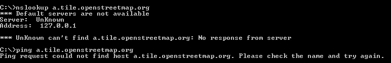
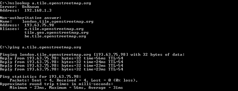
Check the connection from the local network to the online service by using “nslookup” or “ping” from the command line.
If successful check firewall and security settings, see above.
In the example below a connection to the OpenStreetMap service is tested :
- Successful connection
- Failed connection