Import & Geocode
The Import & Geocode tool converts tabular spatial data stored as .csv, .dbf or .txt into a supported vector file.
![]() Dataset List > + button > Import & Geocode
Dataset List > + button > Import & Geocode
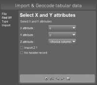
Recognized headers are : x, y, z, latitude, lat, longitude, lon, long, altitude, alt, height.
Do not forget to define the dataset coordinate system after import.
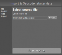
Select source file
Browse and select the resource file.
- Supported files : .csv, .dbf and .txt
- Supported column separators : space, comma, semicolon and tab
- Supported decimal separators : dot and comma (if not used as column separator)
Select the CRS of resource file.
Define x,y,z columns
Define the columns for x, y and optionally z coordinates.
Flag “No column headers” to start the import from the first line (table record).
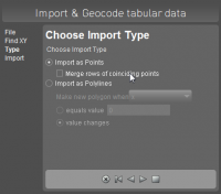
Define spatial component
Import as points
Import coordinates (records) as a separated point object.
Flag “Merge coincident points” to combine records with exactly the same spatial component (x,y,z) into one object.
Import as polylines
Import a list of coordinates (records) as line objects by using an object separator value. The coordinates will be combined into lines as listed in the source file. A well defined column value or a changed column value can be used to separate lists of coordinates into different line objects.
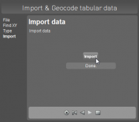
Import data
Click the “Import” button to convert the tabular spatial data into an Orbit vector file. The new dataset will added to the dataset list.
Save imported dataset at the end of the import procedure.