Table of Contents
Clash Detection
This page describes the Orbit desktop extension “Clash Detection”.
Feature Extraction Pro
 Main Toolbar > Extensions > Clash Detection
Concepts
Clusters of Points
Clash Detection identifies a cluster of points within the Volume that is defined by a Vertical Shape, or buffer around this vertical Shape, which is positioned along a 3D Path.
Detected Clusters inside the Shape outline are named Hits. Two buffers around the Shape can be used to analyze Near Hits and Watch List Clusters.
Point Cloud Resource
Clash Detection analyzes single Point Cloud Dataset and is organized in Clash Detection Projects.
Point Cloud Resources must be optimized into an Orbit Point Cloud. If needed merge and optimize multiple Point Cloud Resources into a single Resource, see Orbit Point Cloud and Optimize Data.
File Management
Clash Detection Projects and associated files, like configurations, input and results, are stored and organized by Project next to Point Cloud Resource file : ''<Point Cloud Resource File>.clashdetection/<Clash Detection Project>.
3D Path
The 3D path can be a) an ad-hoc 3D Line Measurement, b) a selected 3D Line Object or c) a Trajectory Segment of a Mapping Run.
Vertical Shape
Simple Shapes are included. Custom Shapes can be imported via a supported vector resource, or drawn using the Clash Detection Shape Design tool.
Sidebar
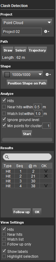
Project
Select Point cloud Dataset
Displays the available opc files in the Dataset List, from which to choose the one on which the clash detection will be calculated.
File menu drop-down
Choose where you want to store the Clash Detection results. A project represents an automatically created destination folder inside your runs pointcloud folder.
For each Clash Detection a new project will be created. Writing new data in an existing project will overwrite existing data in that folder.
Options to create a new project, open a recent project, close or delete a project are available.
Path
There are several possibilities to define the 3D Path:
- Draw - Draw a new path on Map 3D. By pressing Draw again after a path is finished, the vertices of the path can be edited.
- Stop - Finish the drawing of the path.
- Select - Select an existing 3D vector as path.
- Trajectory - Uses the run trajectory as path, which can be selected in Map 2D or Map 3D
The length of the selected path will be displayed. Verify the path length: The length should be less than 2km in order to obtain the best processing performance.
Shape
Drop-down menu
A list of default shapes is available. The dimensions of the predefined shapes can't be modified or deleted. Existent custom shapes can be edited, duplicated, exported or deleted.
- New - Open a new window to draw a custom vertical shape. The central coordinates of the Map Canvas represent the coordinates of the 3D path. Create the new 2D Shape by selecting “New Object” and draw the vertices of the polygon. Construction tools are available for higher accuracy, see Edit Tools and Construction Tools Sidebar. Once done, the shape will become available in the drop-down menu.
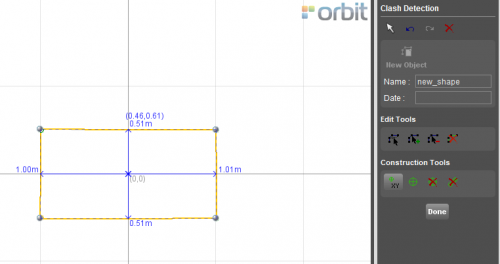
- Import - Imports a previously created 2D Shape in Orbit .ovf format.
- Duplicate- Duplicates the selected custom shape.
- Edit - Reopens the 2D Shape drawing window for editing a custom shape.
- Delete- Deletes the selected custom shape.
Position Shape on Path
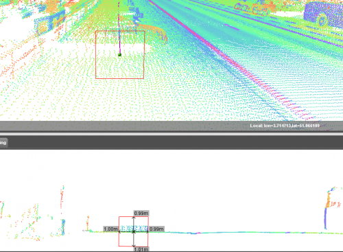
Launches the “Clash Detection” tab, where it is possible to adjust the position of the 2D Shape considering the 3D path.
The central line corresponds to the position of the trajectory path. The Shape must be positioned referencing the defined 3D Path above ground surface.
. The offset values of the 3D Path can be entered inside the corresponding boxes or one can move the entire Shape by click-and-drag. Once the shape is adjusted in the correct location, select “Done”.
Analyze
Define parameters for the detection:
- Hits
- Near hits - A distance parameter must be given.
- Watch list - . The set distance can be greater then the “Near Hits”.
- Ignore ground level - Exclude points from Near Hit and Watch List below the lowest height of the Shape as positioned on the Path.
- Min points for cluster - The minimum number of points to be considered as a “Hit”. The cluster is cumulative, starting for the initially detected points, new points are added to the same cluster if they are in certain 3D distance. If new points are detected at a larger distance from the last detected point in the cluster, they will constitute a new cluster.
- Start
Results
- Type - Type of clash: Hit, Near Hit, Watch List.
- Seq - Detected cluster number in sequence from the start of the Path.
- @m - Distance in meters from the start of the Path.
- OK - Flag on for checked points.
- Follow up - Detected clashes which will not be considerate in the results, such as point cloud noise or ghosts.
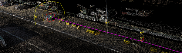
By double-clicking on the results, the Map Canvas and the 3D point cloud view will focus on the location of the detected points.
View Settings
Tools to customize the visualization.
By enabling them it is possible to visualize the Hits, Near Hits, the Watch List as well as to highlight the detected points.