Table of Contents
OSGB 1936 / British National Grid and Local ortho height
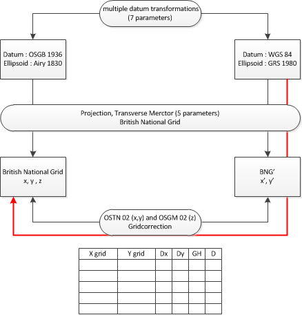
Orbit supports the OSGB 1936 / British National Grid as described by the Ordnance Survey. Both OSTN02 XY and OSGM02 Z grid corrections are implemented.
Related Coordinate Systems
Projected CRS
- 27700 : OSGB 1936 / British National Grid
Vertical CRS
- 5701 : ODN height
- 5740 : ODN Orkney height
- 5741 : Fair Isle height
- 5742 : Lerwick height
- 5743 : Foula height
- 5744 : Sule Skerry height
- 5745 : North Rona height
- 5746 : Stornoway height
- 5747 : St Kilda height
- 5748 : Flannan Isles height
- 5749 : St Marys height
- 5750 : Douglas height
Add CRS Defintion
To use this implementation as defined by the Ordnance Survey :
- Download : ostn02_osgm02_gb.zip (22MB)
- Unzip and Copy to : <Orbit installation directory>/program/system/crs
More Information
- http://www.ordnancesurvey.co.uk (technical specifications about coordinate system)