Table of Contents
Web Based Resources
Web based resources are commonly used for online serving of GIS data, both for vector and image resources.
Orbit supports Web Map Services, Web Map Tile Services, Web Feature Services and Tile Map Services.
Web Services
Web Map Service (WMS), Web Map Tile Services (WMTS) and Web Feature Service (WFS) are the standard protocols of the Open Geospatial Consortium for serving, viewing or editing georeferenced map images and geographical features over the the internet or Intranet using platform-independent calls.
A WMS, WMTS serves georeference map data only. A WFS returns both spatial features and attribute information. This makes it possible to use a WFS dataset for spatial analyses, attribute viewing and if allowed to edit and update the dataset.
More information :
Setup Connection
Orbit provides 2 options to connect and load a web service layer :
Resource Browser service connection
Establish the Web service connection and add one ore more available web service resources.
This user interface method is useful for initial testing of a service and its resources.

- Orbit desktop : Library > Web
- Orbit EOS server : Resources > Datasets > Dataset Setup
Web service resource connection file
Filed based connection to one specific layer of a well defined web service.
Orbit Web service resource connection file.
Supported Versions
Orbit supports Web services as described by the OGC :
Currently Orbit supports :
- WMS versions 1.1.0, 1.1.1 and 1.3.0
- WMTS version 1.0.0
- WFS versions 1.1.0, the support of version 2.0 is on our wishlist. Let us know if you are interested.
Remarks :
- View only (WFS)
WFS support is limited to view only for both spatial and attribute component.
Editing or updating WFS features and styling is not supported.
Via a file based connection an Orbit legend can be defined. - Supported object types (WFS)
Orbit's engine supports only the vector based variant of the following WFS Ojbect types :
Point, MultiPoint, LineString, MultiLineString, Curve, MultiCurve, Surface, MultiSurface, Polygon, MultiPolygon - Internal resource name
No point “.” characters allowed in web resource internal name.
Check the internal name via Dataset Properties > General > Dataset : <Orbit web service name>.<internal web service resource name> .
If the internal name contains one or more points then the resource cannot be used.
WebService CRS and Orbit Map CRS
The Orbit Map CRS will be used to define the Bounding Box of the GetMap WebService map request. To avoid issues like map misalignment due coordinate transformations, set the Orbit Map CRS to a WebService supported coordinate system.
More information about Orbit Map and Dataset CRS, see Coordinate Reference Systems in Orbit.
Examples
No username and password required.
WMS
WFS
Tiled Map Service
Orbit supports pyramid-based tile services as made popular by OpenStreetMap.
Setup Connection
web service resource connection file
Tiled map resource connection file
Configure the tiled map service connection and the web resource to load, cfr web services (see above).
Network connectivity
To use a Web based resource a successful connection to the providing server/service is required.
If no network connection could be established, obviously Orbit will not be able to load the resource. Review the documentation below on how to check the connection from local network to web service.
If a network connection is successful, but Orbit can't load resource, most probably the Orbit application is not allowed to get online/network access due to an internal internet security application (e.g. aXsGUARD Gatekeeper from Vasco). The network and/or local computer administrator need to adjust your security settings or configure a proxy to be used by Orbit :
- Orbit desktop standalone : Orbit GIS Settings.
- Orbit Server and Orbit desktop Client : Orbit Enterprise Service.
Check Local network - Service connection
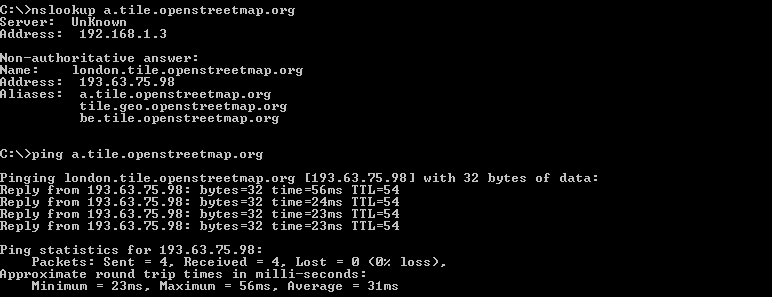
Check the connection from the local network to the online service by using “nslookup” or “ping” from the command line.
If successful check firewall and security settings, see above.
In the example below a connection to the OpenStreetMap service is tested :
Successful connection
Failed connection
