Table of Contents
Position and external orientations
Positions and external orientations at time of recording.
All imagery needs to be properly documented in a photolist as described below.
Please check if the number of images in the image-folder equals the number of lines in this file.
If not, after import you can get a 'File Format Error' warning.
Example of EO file
DSC08610	187963.35883165654	175076.71503390837	126.9	-2.3	-0.3	15.900000000000006
DSC08611	187975.27390620878	175080.01337239612	126.8	0.2	0.1	15.299999999999997
DSC08612	188055.1190617498	175139.6616575243	127.2	6.6	-1.9	13.400000000000006
DSC08613	188048.45164385985	175138.10121865943	127.3	7.8	0.8	13.799999999999997
DSC08614	188037.059979184	175134.8465750059	127.7	4.9	-3.1	12.799999999999997
DSC08615	188025.2127718459	175131.1414321186	127.4	5.0	-0.4	11.5
DSC08616	188013.36508460226	175128.17609145585	127.2	3.0	-0.8	13.400000000000006
DSC08617	188001.76263819545	175125.25706173386	127.2	3.4	-2.5	11.400000000000006
Supported formats
.txt or .csv file.
Specifications
- One EO text file containing the following parameters for all images separated by tabs, semicolon, or white spaces.
- No heading (or column names) [file x y z p r y]
- The GPS positions can be expressed as (X Y Z) or (Y X Z).
- Coordinate reference system of GPS positions can be choosen.
- Z-value: absolute height above sea-level or relative height above given ground height.
- The orientations can be expressed as (pitch roll yaw) (roll pitch yaw) or (yaw pitch roll)
- Yaw: zero degrees pointing North (clockwize positive angle) or zero degrees pointing East (counterclockwize positive angle).
In the documentation below the defaults are described. Coordinate Reference System can be edited.
| Field | Declaration | Units | Necessity |
|---|---|---|---|
| FILE | Image file name or reference to image file. | string | required |
| X | X or Longitude (Easting) of UAV | WGS84 geographic decimal (point) notation | required |
| Y | Y or Latitude (Northing) of UAV | required | |
| Z | Z or UAV GPS height - absolute or relative height above sea/ground level | required |
| Pitch | Vertical angle or inclination about the lateral axes between reference frame and horizontal plane. Positive when reference frame goes up / looking up. Value 0 looking horizontally, value 90 looking vertically at the sky, value -90 looking down. | degrees decimal (point) notation from -90.0 to 90.0 | required |
| Roll | Vertical angle or inclination about the longitudinal axes between reference frame and the horizontal plane. Positive when reference frame rolls to the left. | degrees decimal (point) notation from -180.0 to 180.0 from 0.0 to 360.0 | required |
| Yaw | Horizontal angle between reference frame and north. Positive for clockwise rotation of reference frame. Value 0 looking north, value 90 looking east. | degrees decimal (point) notation from -180.0 to 180.0 from 0.0 to 360.0 | required |
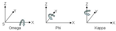
Roll, Tilt (Pitch), Pan (Yaw): Wikipedia Aircraft principal axes