Table of Contents
What is GIS?
A geographical information system is an information system in which (spatial) data or information about geographic objects, called geo-information, can be stored, managed, processed, analyzed, integrated and presented.
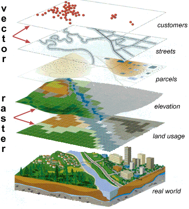
Everything that can be pinned on the earth's surface, may be subject to a GIS. Everything you see on the field can be represented by points, lines or areas. Eg, an address, a street, a lot …

What exactly is the value of a GIS?
Spatial and non-spatial information are combined into one system.
Spatial data: eg lots, buildings, rivers, forests, … contain information on non-spatial data: For instance a lot has a function, an owner, address, …
| Spatial information | Non-spatial information |
|---|---|
 |  |
GIS purposes
For what purposes is gis used today?
- cartography
- logistics
- marketing
- archaeology
- …
GIS developments
The Open Geospatial Consortium (OGC), an international voluntary consensus standards organization, originated in 1994. In the OGC, more than 400 commercial, governmental, nonprofit and research organizations worldwide collaborate in a consensus process encouraging development and implementation of open standards for geospatial content and services, GIS data processing and data sharing.
GIS Software
- ESRI - ArcGIS (World Leader)
- Quantum GIS (Open Source)
- MapInfo
- Autodesk
- Idrisi
- Orbit GIS
- …
Web GIS
- Google Maps, Google Earth (Streetview)
- Bing Maps (Bird's eye)
- WMS services
- AGIV services (eg. Geo vlaanderen)
- …