Mobile Mapping Delivery
This page describes how to use the desktop mobile mapping extension “Delivery”.
The “Delivery” extension makes it possible to export a selection of mobile mapping data in several output formats.
This can be either in Orbit structure or a generic file-format.
![]() Main Toolbar > Extensions > Delivery
Main Toolbar > Extensions > Delivery
Concepts
Sidebar : Ground Control Points
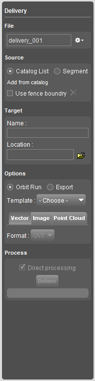
File
Make a new delivery, choose a recent or already existing delivery.
Close delivery to close the current settings. Edits will be saved on the fly.
Delete delivery to delete all the settings for the current delivery.
Source
Catalog list
Add runs from the catalog tab to the delivery.
Segment
Select a segment on the map to use as selection of data to make a delivery.
Target
Insert the target folder name and choose a location to process the delivery
Options
Orbit Run
Choose an Orbit Mobile Mapping Template to define the output structure of your delivery.
Additionally output settings for the vector files, images and point cloud can be defined.
Export
Export the run into generic output-file.
Define the output settings for the vector files, images and point cloud
Process
Click Deliver to process the delivery to the target location.
The processing of the Delivery can be added to the Task Manager.