For documentation on the current version, please check Knowledge Base.
Flightplan Wizard : Generate Stereo Coverage
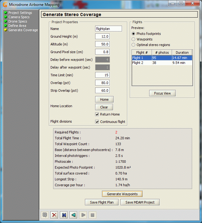
Using this dialog panel we define the next parameters that are free to be changed in function of the local situation and requirements.
Editable Parameters
| Name | The name of the MDAM project. |
|---|---|
| Ground height | The actual ground height above sea level. |
| Altitude | The flying height above the ground. |
| Ground pixel size | The Ground Sample Distance. |
| Delay before waypoint | The amount of seconds that the drone will pause on each waypoint before triggering the image. |
| Delay after waypoint | The amount of seconds that the drone will pause on each waypoint after triggering. |
| Time Limit (min) | The expected battery life time. |
| Overlap | Percentage of model overlap between two images. |
| Strip overlap | Strip overlap percentage. |
| “Home” button | Lets you introduce a position where you expect to lift up the drone. |
| “Clear” button | Clears the 'Home' position. Pressing this button will cause the calculation to ignore a start position and ussumes the drone will lift up always near the location of the first image. |
| Return Home | If this toggle is selected, the drone will be programmed to return to the “Home” position at the end of the flight. This position is either the first image (no home position) or the position selected as 'Home' location. No Return Home means that the drone will descend at the location of the last image. |
| Flight divisions | If this toggle is selected, the flight will be programmed in such a way that the drone will not stop at the trigger locations, but takes the images “on the fly”. This is only possible with the md4-1000. |
Calculation
By pressing the “Generate Waypoints” button, the required waypoints are calculated, together with some statistical data on the flight.
The following statistics are displayed above the “Generate Waypoints” button :
| Required Flights | The number of flights in function of the above parameters. |
|---|---|
| Total Flight Time | The time summed up for all the flights. |
| Total Waypoint Count | The total number of waypoints for the whole of the coverage. |
| Base | The distance between the photocentra. |
| Interval phototriggers | In case of 'Continuous flight' the timelaps in seconds between the images, otherwise zero. |
| Photoscale | The scale of the image according to the given paramaters. |
| Expected Photo Footprint | The dimension of the image surface on the ground. |
| Total surface covered | The surface of the project area covered by the images. |
| Longest strip | The length of the longest strip. |
| Coverage per hour | number of ha covered using these parameters. |
- When the necessary time to cover the area, given the parameters, is larger than the given “Time Limit”, more than one flight will be calculated.
- All calculations are made in the assumption that there are perfect weather conditions during the flight. This means when wind works against the drone, the resulting loss of time is not taken into account and the flights will take more time and battery power than calculated.
The values at the right side display for each flight, the number of images and the flight time needed to execute the flight inclusive the time needed for take off and landing the drone.
Flight Preview Modes
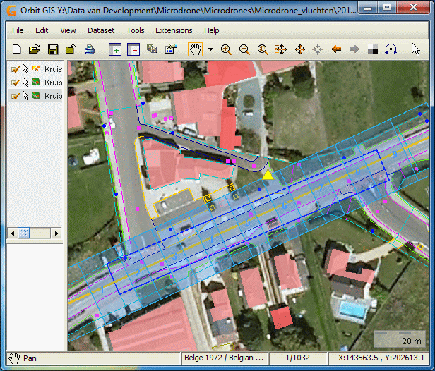
- Show Photos - Shows the images footprint and their overlap.
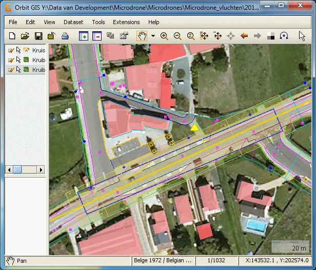
- Show Flight Vector - Shows the strips with the waypoint positions.
- Show Optimal Stereo Regions - shows the areas with optimal stereo visibility.
Below are screenshots of each preview type as visible in OrbitGIS:
Saving the results
After the determination of the flightplan, results must be saved by
- pressing the button “Save Flight Plan”.
- Pressing the button “Save MDAM project”
The first option only creates the different waypoint flight files for use in the Microdrone.
The second option saves all the parameters in an MDAM project file, without creating the waypoint flight files. This MDAM project file can be used afterwards to continue designing the flightplans.
The necessary files are created for each flight. All files are saved after selecting the destination directory.
For each flight, corresponding datasets are created which can be viewed at, using OrbitGIS, at any time.
The following example shows what is saved per flight:
- flightplan_1.txt: an intermediate file containing all waypoints, parameters, and flight commands for the first flight.
- flightplan_eo_wgs84.txt: contains the list of all waypoints from all flights together, expressed in WGS84 with: waypoint number, x,y,z,omega(=0), phi(=0), kappa.
- flightplan_eo_local.txt: contains the same list of waypoints but expressed in the local projection defined in the underlaying map(s).
- flightplan_1_photos.*: the ovf-dataset showing the images footprints for flight 1.
- flightplan_1_waypoints.*: the ovf-dataset showing the GPS waypoints and the flight line for flight 1.
- flightplan_footprint_1.*: the georeferenced image as viewed at in OrbitGIS showing the footprints of flight 1.
- flightplan_waypoints_1.*: the georeferenced image as viewed at in OrbitGIS showing the waypoints of flight 1.
- flightplan_mdam.ovf: contains the extent-area of the area to be covered.
- flightplan.mdam: this is the MDAM project file, containing all the necessary parameters of the project.
The folder “Flight_1” contains only one (1) file called '__WPLIST.TXT' (with two (2) underscores at the beginning of the filename):
There will be created a different folder for each flight needed.


