This is documentation of an archived release.
For documentation on the current version, please check Knowledge Base.
For documentation on the current version, please check Knowledge Base.
Delivery
This page describes the desktop extension “Delivery” for Mobile Mapping.
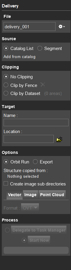
![]() Main Toolbar > Manage > Delivery
Main Toolbar > Manage > Delivery
Concepts
The “Delivery” extension makes it possible to merge Runs or to select an Original Run Segment and to define optionally an area of interest to process and optimize a single Delivered Run or to export the Run resources to any supported format to be used by third party software.
Requirements
Delivery requires :
- An Original Run1) is required to select and export a Run Segment.
To merge Runs any combination of Original, Consolidated or Delivered Runs can be used. - To merge Runs, the image naming requires to be unique over all involved Runs.
- To merge Runs, the Run structure, the dataset structure of the photo positions and coordinate system require to be the same.
Sidebar
File
Make a new delivery, choose a recent or already existing delivery.
Close delivery to close the current settings. Edits will be saved on the fly.
Delete delivery to delete all the settings for the current delivery.
Source
Catalog list
Add runs from the catalog tab to the delivery: right-click 'Add to Delivery'.
By checking the option “Use fence boundary”, a part of the selected catalog runs can be delivered. The fence selection is based on geographical location. A fence can be created using Construction Tools. By selecting multiple runs from the Catalog, a merged run can be created.
Segment
Select a segment on the map to use as a selection of data to make a delivery. The segment option selects a part of the trajectory, based on timestamps. Pointcloud, images, and trajectory captured within the same timeframe will be exported.
Clipping
Choose if and how you want to clip the selected run(s) based on a spatial reference.
- No clipping
- Clipping by Fence: Create a fence as a Construction. The result run or export will be that part of the run(s) that is inside the fence.
- Clipping by Dataset: Select one or several areas from a vector file. There will be a result run or export for each area.
Target
Insert the target folder name and choose a location to process the delivery
Options
Orbit Run
Choose an Orbit Mobile Mapping Run to define the output structure of your delivery.
Additionally, output settings for the vector files, images, and point cloud can be defined.
No trajectory file is exported, with the exception of exporting a run part using the “Segment” option.
Create image subdirectories when merging multiple Runs with the same naming convention. Inside the metadata folder of the delivered Run, a file is created that contains an overview of delivered runs and the corresponding subdirectories.
Export
Export the run into generic output-file.
Define the output settings for the vector files, images, and point cloud.
No trajectory file is exported.
Process
Click Start Now to process the delivery to the target location.
The processing of the Delivery can be added to the Task Manager.
1)
Original Run : Run of Version 3 as used since Orbit 11.0, see Orbit Mapping Resources - Structure and Configs
Last modified:: 2023/05/12 16:31