For documentation on the current version, please check Knowledge Base.
Clearance Checker
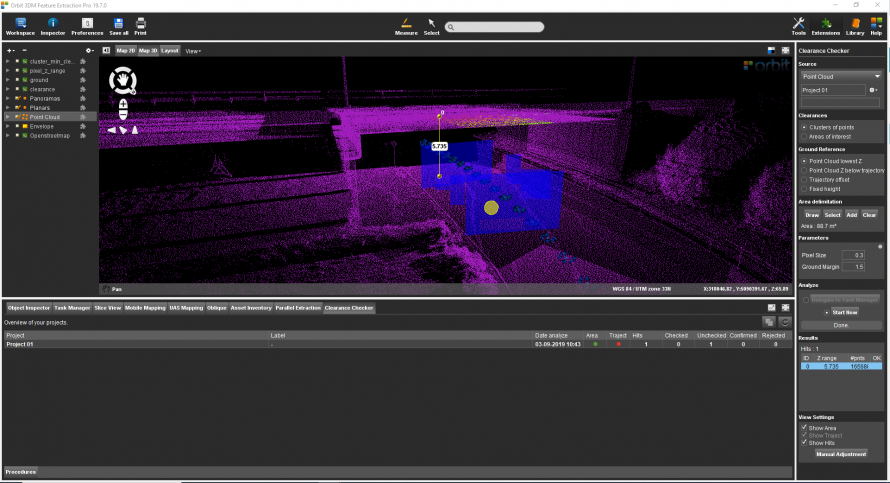
This page describes the Orbit desktop extension “Clearance Checker”.
![]() Main Toolbar > Extensions > Clearance Checker
Main Toolbar > Extensions > Clearance Checker

Concepts
The Clearance checker extension calculates the lowest clearance of overhanging objects or constructions above a surface.
Source
Use the generic workflow for Point Cloud Based Extensions to define the source file.
The method for the range of interest is 'Path', 'Multiple Paths', 'Area' and 'Multiple Areas'.
Group By
Clusters
For every area or path, the point cloud gets divided into clusters. For each cluster, the lowest clearance will be calculated.
Ranges
For every area or path, the lowest clearance will be calculated.
Ground Reference
Choose one of the below-described options to define the Ground Reference:
Point Cloud lowest Z
The lowest z-value of the point cloud.
Point Cloud Z below trajectory
The lowest z-value of the first point cloud cluster found below the trajectory.
Trajectory offset
Enter a fixed vertical offset from the trajectory - Ref. Advanced Parameters (see below).
A trajectory needs to be defined in block Trajectory: a new path can be drawn or selected.
Fixed height
Enter a fixed z-value - Ref. Advanced Parameters (see below).
Use paths
The source path(s) are used to set the ground reference.
Parameters
Define parameters for the detection:
Pixel Size
The pixel size defines the grid size of the DEMs that are created. For every pixel, the lowest clearance is calculated.
Ground margin
The vertical offset between the Ground Reference that will be excluded from the analysis.
Slice Thickness
Horizontal sliced are used to define ground and ceiling within each pixel. If a slice with a minimum number of points is found above ground height, then the clearance for that pixel is defined.
Fixed Ground Height
The value for the fixed ground height, available when ground reference is Fixed height.
Trajectory Offset
The fixed offset from trajectory, available when ground reference is Trajectory offset.
Advanced Parameters
The advanced set of parameters can be accessed by small grey circle in top right corner of block Parameters.
Algorithm
- Pixel Pts Min: The minimum number of points from the point cloud within a pixel. Pixels that include less points are not used to define floor and ceiling.
- Slice Pts Min: The minimum number of points in a horizontal slice to define floor and ceiling of a pixel.
- Clearance Pixels Min: The minimum number of pixels a cluster should have. The final floor and ceiling are defined by a cluster of pixels.
- Point distance: The distance between line points to check clearance by line.
- Context radius: The radius to use around line points to check clearance.
- Context Pts Min: The minimum number of points in the context of a line point.
- Clearance Max: If not zero, clearances above this value will not be considered.
Output
- Missing Sample: The value that will be used for the clearance.omi raster created if there are no overhanging objects (default = -9999).
- Get point cloud as selection: Get a point cloud selection file of the clearance points.
- Get point cloud attributes: Get a point cloud attribute file with clearances.
- Get intermediate rasters: Get rasters created to detect clearance. Only available for clearances by area and clusters.
Results
The Hit count is the number of clearances found.
- Z range: Value of the clearance.
- #pnts: Number of points defining the ceiling of the clearance.
DEM files are added to the Dataset List by default and are saved in the corresponding folder (see above).
- Clearance
- Cluster_min_clearance
- Ground
- Pixel_z_range
Clearance Checker Tab
In the Clearance Checker Tab all Clearance Projects are shown including the results and metadata. Standard operations like detaching and maximizing tab are available.
