This is documentation of an archived release.
For documentation on the current version, please check Knowledge Base.
For documentation on the current version, please check Knowledge Base.
Preferences of Terrestrial Mapping
This page describes the preferences related to Terrestrial Mapping extension
![]() Main Toolbar > Preferences > Terrestrial
Main Toolbar > Preferences > Terrestrial
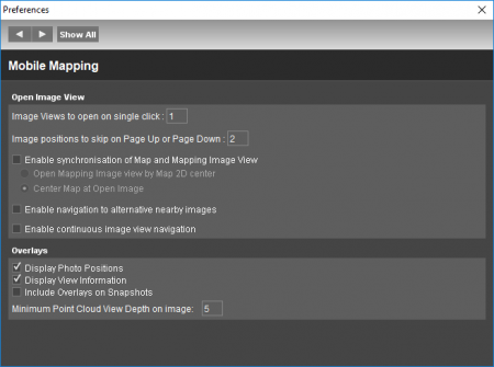
Settings
- Option to display photo positions as overlay on Mapping views .
- Option to display metadata of the opened image (id and timestamp) and current view (position and orientation) as overlay on Mapping views.
- Option to include all overlays (photo positions, metadata, vector data and measurements) on snapshots.
- Set number of images to open with single click on Map, see Open Image or 3D View from Map.
- Set minimum point cloud view depth when displaying the point cloud on image, see Point Cloud Legend & Viewing Restrictions.
Last modified:: 2023/05/12 16:31