For documentation on the current version, please check Knowledge Base.
Map Statusbar
This page describes all functions and use of the “Map Statusbar”.
The Map Status bar displays and gives access to the current map view status. Also the active map function is indicated.
![]() Map > Statusbar
Map > Statusbar

Active map function
(1) Display active map function
The active map function is displayed at the left-hand side. Some map functions do also update the mouse pointer appearance when hovering above the map.
Map CRS
(2) Display and set map coordinate system
A single click on the current map crs will open the “Coordinate Reference System selection” window to change the map crs.
All resources are displayed in the map coordinate reference system. If the dataset crs differs from the map crs than the dataset will be re-projected on the fly to be displayed.
More information and advises on the map crs : Coordinate Reference System in Orbit > Map CRS
Map Scale
(3) Display and set map scale
A single click on the current map scale will open the “Set Scale” window to select a preset scale or enter a specific value.
The scale unit is defined by the map crs. For projected coordinate systems will be “meter” or “feet”. Geographical coordinate systems will use “degrees”.
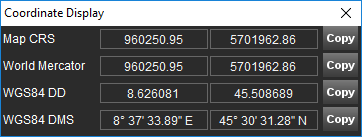
Coordinate Display

(4) Display map and world coordinates
A single click on the cursor map coordinates opens the “Coordinate Display” window.