For documentation on the current version, please check Knowledge Base.
Pix4D
This page describes the original Pix4D aerial mapping resources for Orbit import.
Use the corresponding Orbit Import Template to import the described original data.
It is recommend to read first Orbit Mapping Resource.
Nadir Planar Images
Image files
- Image type: Undistorted (corrected distortion and Central Principal Point) planar images. To export undistorted images in Pix4D, select 'Process' in the main menu of Pix4D, and select the method “Save Undistorted Images”.
- File format: Each image is one *.jpg file.
- Filename: Exactly as in image positions file, see below.
- Folder structure: All files in one folder.
Image Positions File
- File format: One text file.
- File structure Rows: the first line is the header, each image is one record.
- File structure Columns: space-separated (char9), with exact order as the example below (more columns are allowed but first 7 should be as shown below).
- Value of Filename: Filename as on disk, with file extension.
- Value of Coordinates: any supported coordinate system can be used, Long/Lat order for geographical coordinates, decimal notation, without thousands separator.
- Value of Angles “Omega;Phi;Kappa” : Omega, Phi, Kappa orientation angles, degrees.
imageName X/Long Y/Lat Z Omega Phi Kappa
DJI_0870.JPG 2482725.560659 345684.821469 895.604221 -4.006029 -3.705921 -109.091568
DJI_0871.JPG 2482790.515404 345685.483699 896.707002 0.715067 -4.706115 -91.972336
DJI_0872.JPG 2482858.858022 345686.206525 897.050719 1.696087 -4.566736 -91.108750
...
Camera calibration file
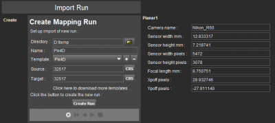
The camera calibration information can be found in the “Quality Report” exported from Pix4D
- File format: One *.cam file, containing among others camera calibration information (camera name, sensor width in mm and in pixels, sensor height in mm and in pixels, focal length and principal point x/y) and CRS.
The camera calibration parameters must be entered before Create Run, the 1st step of the Import Run procedure.
To facilitate import, your specific camera calibration values can be registered inside the Orbit template to avoid entering these values at import each time. Contact Orbit Support if assistance is needed.
Point Cloud
- File type: Densified point cloud.
- File format: One or more *.las files.
- File structure: Las version 1.2.
Orthomosaic
- File format : Any supported image data format.
The ortho is not a part of the UAS Mapping Run, it can be added separately to the Map view.
Convert the Orthomosaic file into *.omi format for enhanced performance.