For documentation on the current version, please check Knowledge Base.
Optimize Data
This page describes the desktop tool “Optimize”.
![]() Tools > Optimize
Tools > Optimize
Drag & drop of a resource file that requires to be optimized for display will open this sidebar automatically.
Concepts
The Convert and Optimize Tools enable import, export, and possible data optimization of Reference Resources.
“Optimize Data” optimizes one or more supported resource files into a single Orbit optimized resource file.
“Convert Data” converts any supported resources file into another supported resource file, one on one.
One and the same sidebar is used to optimize all supported Reference Resource datatypes.
Optimizing original spherical images of mobile mapping resources to processed OMI images needs to be done using the “Optimize Imagery” procedure, see Optimize Imagery 1).
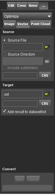
Source
Set the source file or the source directory.
- When activating the option source file, it is possible to drag and drop the resource file inside the entry field.
- When using a source directory, all supported resource files of the specified data type inside the selected source directory and, optionally, its including subfolders will be optimized.
Target
Set the target file and directory.
- The source directory and filename are preset as default target file and directory.
- For point cloud data, a target CRS is required. The source CRS is preset as default.
- Optionally when processing is completed, add optimized resource automatically to the dataset list.
Options

The tool optimizes source data into the corresponding native Orbit file formats. Use the convert tool to export data into 3rd party supported storage formats.
Point Cloud
Options for Point Cloud data, see Orbit Point Cloud.
- Ascii source files
- Strip Attributes
- Filter points
- Density
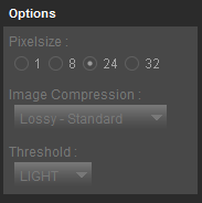
Image data
Options for Image data, see Orbit Multiresolution Image.
- Pixel size
- Image compression
- Threshold
Convert
Start process.
Upon cancellation, the ongoing process will be interrupted and if possible the preliminary target file will be created.