For documentation on the current version, please check Knowledge Base.
Preferences of Map Canvas
This page describes the preferences related to Workspace framework.
![]() Main Toolbar > Preferences > Map Canvas
Main Toolbar > Preferences > Map Canvas
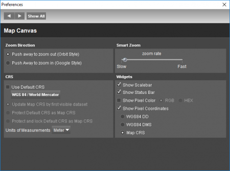
Zoom Direction
It is possible to change the direction of the smart zoom ( also the Mouse scroll ) Orbit Style | Push or scroll away to zoom out. Google Style | Push or scroll away to zoom in.
Smart Zoom
To adjust the smart zoom rate and the smart zoom factor: Set smart zoom rate | Increase the zooming speed by setting the zoom rate faster. The smart zoom will zoom in and out slower or faster according to the adjustments.
CRS
Gives different possibilities to define the MapCanvas Coordinate Reference System (CRS):
- Use default CRS: the default CRS will be used to display all datasets that do not have a defined CRS.
- Update map CRS by first visible dataset : the map will be displayed in the CRS of the first visible dataset.
- Protect default CRS as map CRS : the map CRS will be displayed in the default CRS if the map CRS is not changed manualy.
- Protect and lock default CRS as map CRS : it will be imposibile to change the map CRS without changing the preferences settings.
Units of Measurements
Define the unit of measurement for the Map Canvas. There are three options:
- Meter
- Yard
- Foot
The result of a relative measurement (length, distance, area, volume) will be expressed in the chosen unit. An absolute measurement (2D/3D coordinates) are expressed in the MapCanvas coordinate system. This also includes the vertical coordinate system.
When a measurement is copied to feature, it will always be saved in the unit of the vector file it was copied to.
Widgets
Show or hide some widgets/tools : the scale bar, the status bar or pixels color and coordinates