For documentation on the current version, please check Knowledge Base.
Convert Data
This page describes the desktop additional tool “Convert”.
![]() Tools > Convert
Tools > Convert
Concepts
The Convert and Optimize Tools enable import, export, and possible data optimization of Reference Resources.
“Convert Data” converts any supported resources file into another supported resource file, one on one.
“Optimize Data” optimizes one or more supported resource files into a single Orbit optimized resource file.
One and the same sidebar is used to optimize all supported Reference Resource datatypes.
Optimizing original spherical images of mobile mapping resources to processed OMI images needs to be done using the “Optimize Imagery” procedure, see Optimize Imagery 1).
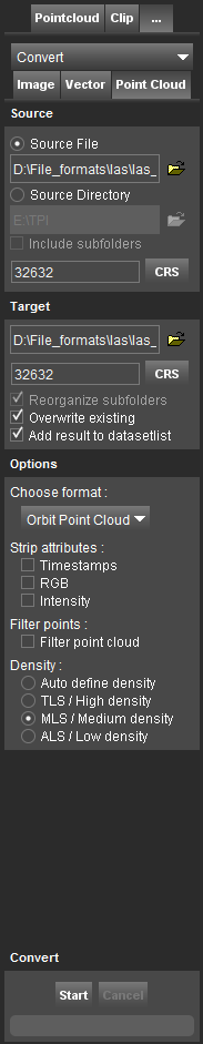
Source
Set the source file or the source directory.
- When activating the option source file, it is possible to drag and drop the resource file inside the entry field.
- When using a source directory, all supported resource files of the specified data type inside the selected source directory and, optionally, its including subfolders will be converted.
Target
Set the target file when converting a source file, or the target directory when converting a source directory.
- The source directory and filename are preset as default target file and directory.
- For point cloud data, a target CRS is required. As default the source CRS is preset.
- Optionally when converting a source directory including all its subfolders, re-create the source directory tree inside the target directory.
- Optionally, overwrite existing target files.
- Optionally if target a native Orbit storage format, add converted resource to the dataset list when processing is completed.
Options
File storage options :
- Format: Target resource file storage format.
Image data
Options for Image data only.
BMP : Bitmap Image
See Wikipedia, BMP file format.
- Pixel Size : Number of bits to store one pixel. 8-bit pixel to display 256 colors, 24 to display true colors (16,7 million colors).
GIF : Graphics Interchange Format
See Wikipedia, GIF.
- Interlace : See wikipedia page above > Interlacing.
JPG, JPEG : Joint Photographic Experts Group
See Wikipedia, JPEG.
- Quality : Set JPG compression quality poor (25), average (50), good (75), excellent (90) or custom.
It makes no sense to set target quality higher than quality of source.
OMI : Orbit MultiResolution Image
See Orbit Multiresolution Image
TIFF : Tagged Image File Format
See Wikipedia, Tagged Image File Format.
- Image Type :
- Monochrome image : 1 bit/pixel, black or white.
- Grayscale image : 8 bits/pixel, 256 shades of gray.
- Truecolor image : 24 bits/pixel, 16M colors.
- Image Compression : Uncompressed / JPEG
- File Structure :
- Striped : Baseline tiff image file by Strips, slower reading but higher compatibility.
- Tiled : Tiff image file by Tiles, faster reading but lower compatibility compatible.
- Multiresolution : Option to add multi resolution sub-levels to improve image reading performance.
Vector data
The export storage format must support the dataset structure, see Vector Data Structure.
Options for vector data formats: *.GPX , *.KMZ , *.KML , *.DXF , *.OVF , *.OVT , *.OXF , *.SHP .
Point Cloud
Options for Point Cloud data, see Orbit Point Cloud.
- Ascii source files
- Strip Attributes
- Filter points
- Density