For documentation on the current version, please check Knowledge Base.
Measurements using Point Cloud
This page describes the concept and some related settings of measuring using point cloud.
More information related to mobile mapping measurements on Orbit Desktop and Orbit WebClient :
- Desktop : 3D Measurements
- WebClient : MM View > Measurements
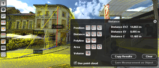
Flag the check box “Use Point Cloud” on the Measure window.
Point Cloud Measure Technique
In Desktop one can set via the 3D Hover, see Preferences of 3D Hover and Measure Techniques.
Closest Point
The measurement technique Closest Point selects automatically the nearest point available of the point cloud, considering the XYZ of the startup measured point. Closest Point technique is advised for high density point clouds.
Flat Surface Intersection
In the flat surface intersection, a point is created using interpolation method within the range of a set of pre-defined point cloud points. It is possible to configure settings such as search radius and minimum number of use points in the Preferences of the 3D Hover. The flat surface Intersection technique is advised for less dense point clouds.
Ridge and Corners Intersection
Ridges and corners Intersection technique follows the same principles of flat surface intersection interpolation method and identifies where edges, ridges and corners are existent, for example, in the side of roads and corners of buildings.
Measurement techniques in Flash WebClient
In Flash WebClient, default Flat Surface Intersection is used. The measurement technique “Closest Point” is also available. This configuration must be set manually, by accessing the file server.ini and uncomment (remove the # of) line publisher.pointcloud.intersection.technique closest_point:
../server/program/config/server.ini
...
#publisher.pointcloud.intersection.minimum.distance		0.5
#publisher.pointcloud.intersection.minimum.point.count	25
#publisher.pointcloud.intersection.minimum.size			5
#publisher.pointcloud.intersection.maximum.size			25
publisher.pointcloud.intersection.technique			closest_point
...
Restrictions by Legend
If the Orbit Desktop has direct file access to the Orbit Run containing the Orbit Point Cloud files coordinate measurements using point cloud are calculated client side according the principle of “what you see is what you get”1) and Orbit Desktop's 3D Hover setting :
Point Cloud measurement on Images
The Orbit Mapping Desktop Clients are using Orbit's generic 3D Hover concept, see above “Preference of 3D Hover”.
One extra functionality is added. On using the Mobile Mapping Image View the point cloud doesn't need to be set visible on the image to be used by the 3D Hover. The Point Cloud Legend and Viewing Restrictions are taken into account at all time, even if the point cloud is set to be invisible.
Direct File Access
Point Cloud Streaming
Point Cloud Service
Available for Orbit Desktop and Orbit Flash WebClient.
When using a point cloud service, coordinate measurements are requested from the point cloud service. The client only displays the coordinate measure result as calculated and returned by the service.
There is no 3D Hover nor settings to specify the point cloud measure technique.
The Orbit Publisher point cloud service does allow point cloud overlay and measurements.
The composite Project point cloud can be displayed as overlay on image according the server side point cloud legend setting.
Measurements are computed server side by flat surface intersection on the point cloud of the Run of the used image only. The composite Project or Category point cloud is not used for measurements.
The Orbit Flash WebClient supports the Orbit Publisher point cloud service only.
In Orbit Desktop, point cloud files can be used, as well an Orbit Publisher Publication offering a point cloud service can be opened.