For documentation on the current version, please check Knowledge Base.
Prepare Riegl MM Resources
This page describes Riegl Riprocess mobile mapping resources and Riscan terrestrial mapping resources for Orbit.
Using the according Orbit Import Templates the described resources can be imported into Orbit.
It is strongly recommend to read first Concepts of Mobile Mapping and UAS data in Orbit.
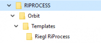
Riegl Templates
RiScanPro
Download the static import template here, 3D Mapping Data Preparation and Import Templates.
Consult the section of 'Resources' below to know how the import files should be prepared when using this template.
RiProcess
Update RiProcess Installation
The Orbit Import Templates are generated exported by RiProcess.
When using a version of RiProcess released before June 2018, you need to update the Riegl Reference Orbit Template files included inside your RiProcess setup.
Download the Riegl Reference Orbit Template files using the link below and update the folders as indicated by the screenshot at the right.
Riegl RiProcess
Steps to export data from Riprocess
Export Trajectories
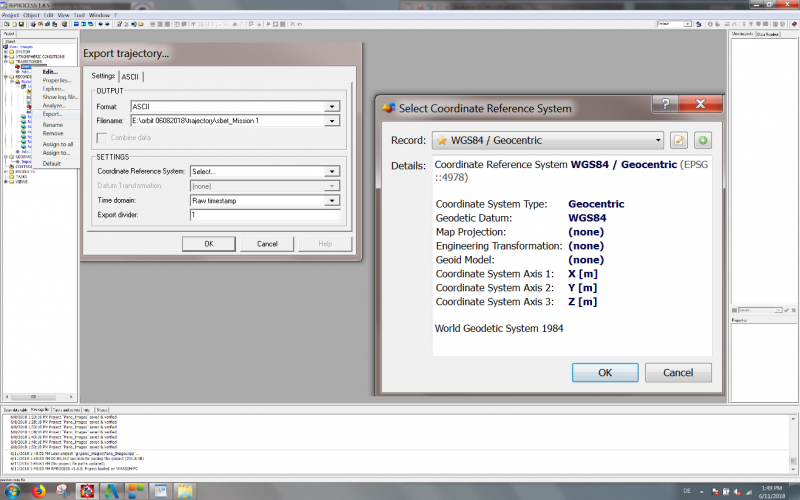
- Right-click on Trajectories/Export …
- Select Coordinate System, e.g select GEOCENTRIC Coordinate System
- Select an output location and name for the trajectory.
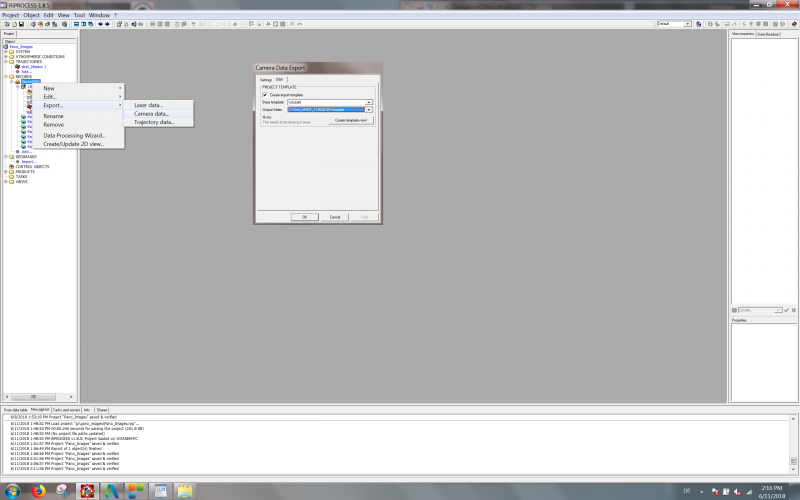
Export Camera data
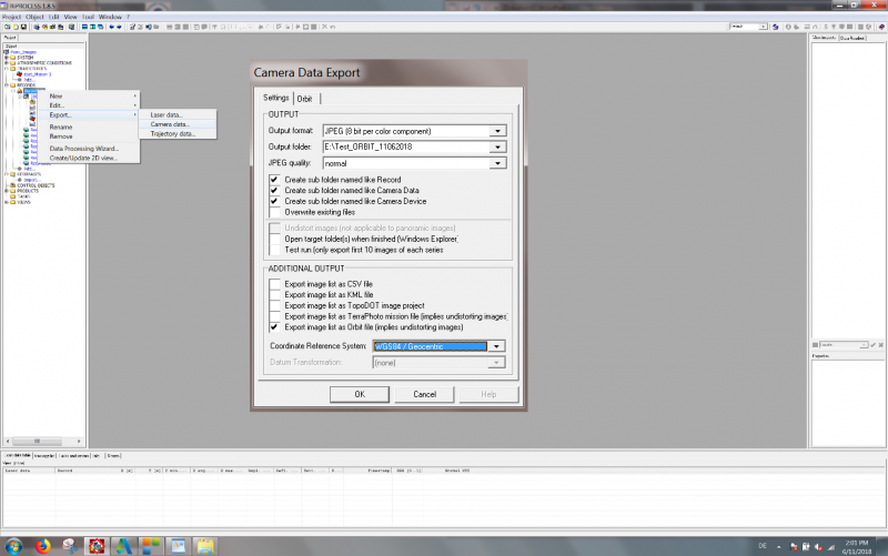
- Right-click on Record/Export/Select Camera data …
- Select Coordinate System, e.g GEOCENTRIC Coordinate System
- Select an output location and name for the imagery.
Export Laser data
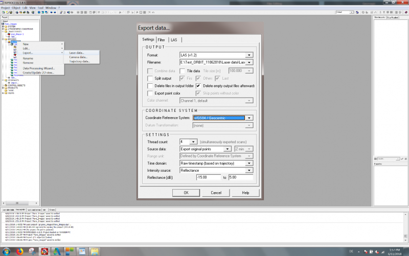
- Right click on Record/export/select Laser data …
- Select Coordinate System, e.g select GEOCENTRIC Coordinate System
- Select an output location and name for the pointcloud.
Export Orbit template
- Right-click on Record/export/select Camera data …
- Select the template, e.g. Riegl RiProcess.
- Select an output location and name for the template.
- Press on Create template now!
- A message Template created successfully should appear.
Resources
Trajectory
Applicable for RiProcess.
Trajectory positions file
- File format : One ASCII *.csv file.
- File structure Rows: Each trajectory timestamp is one record.
- File structure Columns: Comma separated (char44), headers, with exact order as the example below.
- Value of Coordinates: any supported coordinate system can be used, Long/Lat order for geographical coordinates, decimal notation, without thousands separator.
- Value of Timestamps: GPS Absolute time or GPS Week time, decimal notation.
Time[s],Easting/Long[m],Northing/Lat[m],Elevation[m],Roll[deg],Pitch[deg],Yaw[deg]
224890.057239,547142.912,5390005.558,364.853,2.053063914342,3.487736106196,17.974253626389
224890.062239,547142.913,5390005.638,364.915,2.057884034006,3.488899462515,17.971361583690
224890.067239,547142.914,5390005.718,364.977,2.065638026294,3.490579275132,17.971408047112
...
Panoramas
Applicable for RiScanPro and RiProcess.
Image files
- Image type : Ladybug 5, equirectangular panoramas.
- Image resolution : Ratio 2×1, advised 8000×4000 pixels.
- File format : Each image is one *.jpg file.
- File name : Exactly as “Filename” value of image positions file, see below.
- Folder structure : All files in one folder.
Image positions file
- File format: One ASCII *.csv file.
- File structure Rows: Each image is one record.
- File structure Columns: Comma separated (char44), headers, with exact order as the example below.
- Value of Image ID: “Filename” value, filename as on disk with file extension, see below.
- Value of Coordinates: any supported coordinate system can be used, Long/Lat order for geographical coordinates, decimal notation, without thousands separator.
- Value of Timestamps: Same Time Reference as Trajectory, see above.
Timestamp,Filename,Origin (X/Long,Y/Lat,Z),Direction (X,Y,Z),Up (X,Y,Z),Roll(X),Pitch(Y),Yaw(Z)
186594.2246,141111_040847143.jpg,-1500901.377,6196894.024,163467.166,0.228739827,-0.029419842,0.973042941,-0.230119866,0.969581069,0.083411016,-68.79688049,-76.6661872,-7.328978157
186594.6487,141111_040847567.jpg,-1500902.338,6196893.931,163462.369,0.214075245,-0.024180399,0.976517843,-0.233535976,0.969435754,0.075201508,-69.56981959,-77.55886068,-6.444404969
186595.0726,141111_040847991.jpg,-1500903.234,6196893.856,163457.664,0.198904143,-0.029530112,0.979573945,-0.241949569,0.967125721,0.078283117,-67.08873747,-78.39962836,-8.444678498
...
Planars
Applicable for RiProcess.
Image files
- Image type: Rectified, undistorted images.
- Image resolution: According to the camera calibration.
- File format: Each image is one *.jpg file.
- Filename: Exactly as “Filename” value of image positions file, see below.
- Folder structure: All files in one folder for each camera.
Image positions file
- File format: One ASCII *.csv file.
- File structure Rows: Each image is one record.
- File structure Columns: Comma separated (char44), headers, with exact order as the example below.
- Value of Image ID, “Filename”: Filename as on disk, with the file extension.
- Value of Coordinates: any supported coordinate system can be used, Long/Lat order for geographical coordinates, decimal notation, without thousands separator.
- Value of Timestamps: Same Time Reference as Trajectory, see above.
Timestamp,Filename,Origin (Easting/Long,Northing/Lat,Elevation),Direction (Easting,Northing,Elevation),Up (Easting,Northing,Elevation),Roll(X),Pitch(Y),Yaw(Z)
45284.575200000,110908_123444575_Camera 1.jpg,548324.806,5390541.554,360.528,-0.676989013,-0.570078724,0.465506310,0.611061083,-0.787898665,-0.076289229,9.307168536,-61.874787478,29.572965242
45285.575188000,110908_123445575_Camera 1.jpg,548321.543,5390544.827,360.621,-0.843145235,-0.302017244,0.444850196,0.292203020,-0.951872662,-0.092497734,11.746162447,-62.995967811,6.571362402
45286.575177000,110908_123446575_Camera 1.jpg,548319.572,5390549.399,360.736,-0.892828041,0.006230655,0.450354602,-0.050736548,-0.994924680,-0.086894675,10.920878255,-62.719427866,-12.648428546
...
Camera calibration
Camera calibration settings are included in the Riegl RiProcess exported Orbit Template.
Point Cloud
Applicable for RiScanPro and RiProcess.
LiDar files
- File format: One or more *.las files.
- File structure: Las version 1.2.
- Value of Coordinates: Same CRS as Trajectory, see above.
- Value of Timestamps: Same Time Reference as Trajectory, see above.
- Riegl export settings: enable setting “Use Compatibility mode : Exclude Extra Bytes”