For documentation on the current version, please check Knowledge Base.
|
|
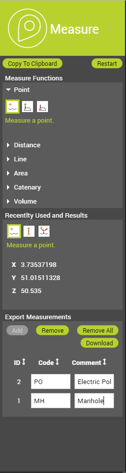
Measure SidebarThis page explains the Measure Sidebar of the 3D Mapping Cloud Viewer and 3DM Publisher HTML5 Viewer and how to use it. Different types of measurements can be performed on the Reference View and the Views. With the Measurement Sidebar one can choose the measurement function, view the results and export the measurements as a feature layer. Measure Functions
Measure Mode
Activate measure function All measurement functions are described on this page: Basic 3D Measurement Functions.
Perform measurement It is possible to start a measurement in one view and finish it in another view. This is of course depending on the measurement technique that is chosen. While the measurement is active, pan, zoom and navigate options are still available. The Quick Navigation Guide holds the explanation of these options and can be reached via the More Menu. Specifics on measuring in a Spherical View Mode:
Recently Used and Results
Recently Used
The icons of the measurement tools that were used in the current session are listed here.
Results
Results from absolute measurements (point coordinates) are displayed in the active CRS of the publication. The default CRS is WGS84 decimal degrees. Switching between WGS84 decimal degrees and any CRS of the published resources is accessible via the Settings Menu in the left lower corner. Results from relative measurements (distances, areas) will be calculated in an on-the-fly calculated local projection centered around the first measured coordinate. This local projection returns the most realistic metric result at all time. Export Measurements
|