For documentation on the current version, please check Knowledge Base.
Measure Sidebar
Concepts
The Measure Sidebar allows to perform different types of measurements as well as saving and downloading as feature layers.
Measure Functions
Measure Mode
The measurement technique can be chosen in the Settings Menu.
Activate measure function
Start the desired measurement function with a single click on the corresponding icon.
- If a measure function is activated the appearance of the cursor changes in a rectangular cross when hovering the mouse pointer above a view.
- If a measure function is activated the zoom, pan and navigate functions are still available.
Measurement Tools
All measurement tools are described on this page: Measurements.
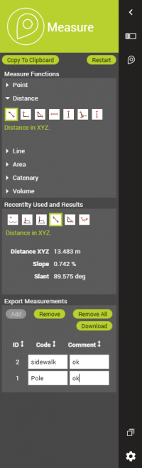
Recently Used and Results
Recent Functions
All the measurement tools used in the current session.
Results
Absolute (point coordinates) measurements results are displayed in WGS84 decimal degrees and in the CRS of any resource added to the publication.
Switching between WGS84 decimal degrees and any CRS of the published resources is accessible via Settings Menu in the left lower corner.
Relative measurements (distances, areas) will be calculated in an on-the-fly calculated local projection centered around the first measured coordinate. This local projections returns the most realistic metric result at all time.
Export Measurements
- Add: the displayed measurement result will be copied to a table. For every added measurement code and comment information can be added.
- Remove: selected measurement result will be removed from the table.
- Remove all: all measurement results will be removed from the table.
- Download: all results added in the table will be downloaded into “3DMappingCloud-Measurements-Export.kml” file.