For documentation on the current version, please check Knowledge Base.
Annotations Sidebar
Concepts
The Annotations Sidebar allows drawing of simple annotations on any HTML5 view.
Annotations are tools to complement the map data with temporary notes or sketches in the currently opened viewer. Orbit provides a range of annotation types that can be stored in an annotation file. This annotation file is saved separately as an .o3a file and is not a fixed part of the viewer or publication.
Though since Orbit annotations are georeferenced, they remember exact positions and can be exchanged with colleagues. Just download them as an .o3a file that can be shared.
An Annotation consists out of an Annotation Objects.
Create annotations
An Annotation Object can be a point, a line, a polyline, a free line, a free area, a circle or a text tag.
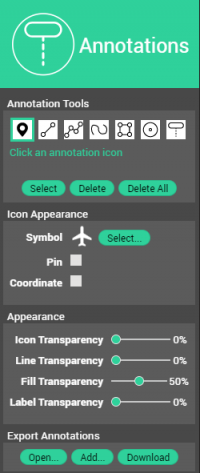
Icon Appearance
Depending on the chosen annotation type, options to customize the appearance of the annotations.
For example, options to choose a particular symbol from an available library, to modify the color and the color width, or to show next to the annotation the coordinates.
Global Appearance
Options to adjust the transparency of all annotation points, lines, areas or text labels.
Export Annotations
- Open: Open an existing HTML5 annotation file.
- Add: Open a new annotation file to combine the annotations with the existing ones.
- Download: Download the created annotations that can be shared with colleagues.