This is documentation of an archived release.
For documentation on the current version, please check Knowledge Base.
For documentation on the current version, please check Knowledge Base.
Settings Menu
Publication user preferences. Adjusting these setting is applicable for the current session only.
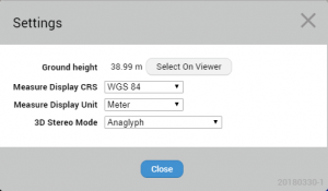
Ground height
Allows to pick the ground height value by clicking in one of the 3D views.
The value is used for displaying on the views 2D resources and is calculated as follows:
- On any image view : Z coordinate of the photo position view point minus the height offset of the camera above ground, see Orbit run configuration.
- 3D point cloud view : Z coordinate of the 3D view point downwards intersection with the point cloud. This technique will only be used if no image view has been opened.
Measure Display CRS
Allows to select a CRS for displaying measurements results. By default WGS84 will be used, additionally measurements results can be displayed in the CRS of any resource included in the publication.
Measure Display Unit
Allows to select meter, foot or yards as measuring unit.
3D Stereo Mode
Choose from different stereo techniques to display the 3D View.
Last modified:: 2019/03/25 11:36