For documentation on the current version, please check Knowledge Base.
Dataset Structure - Naming
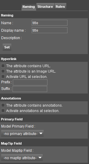
Naming
Select a Model, Attribute Set or Attribute in the Dataset Structure Tree at the left hand side to change the name or displayname of the selected component. Use the “Set” button to apply edits.
The Model, Attribute Set and Attribute displayname are used by the Object Inspector, Dataset Legend Editor and Dataset Attribute Table View.
Hyperlink
Select an Attribute of Datatype String in the Dataset Structure Tree at the left hand side to configure the Attribute as Hyperlink Attribute.
- Attribute contains hyperlink.
- Hyperlink refers to an image.
- Open hyperlink automatically at object selection.
- Hyperlink Prefix / Suffix : Optionally, hyperlink is
Concat(Prefix,AttributeValue,Suffix).
An Attribute Hyperlink can be opened from the Object Inspector or WebClient Image and Object Metadata Window. In an Orbit Desktop the hyperlink can be triggered automatically at selecting the object if the according hyperlink option is enabled.
An Attribute Image Hyperlink can be used by the Dataset Legend Editor to render the Label as image, see Dataset Legend : Labels.
Annotations
Select an Attribute of Datatype String in the Dataset Structure Tree at the left hand side to configure the Attribute as Annotation Attribute.
- Attribute contains annotation.
- Open annotation automatically at object selection.
An Attribute Annotation can be used to link and save an Annotation with an Object. Display and editing the Attribute Annotation is initiated from the Object Inspector.
Primary Field
Select a Model to set its Primary Attribute.
The Primary Attribute is used as object identifier in the Object Inspector's Object List. The default Object List identifier is the Spatial Object ID.
Maptip Field
Select a Model to set its Maptip Attribute.
The Maptip Attribute of the Active Dataset is displayed in a yellow box when hovering the cursor above the Object on the Map 2D.