For documentation on the current version, please check Knowledge Base.
Orbit SDK Capabilities and How to Make a Plugin
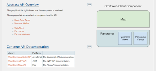
Making Plugins : Introduction to the SDK
Using the Orbit Mobile Mapping Publisher SDK (dot net, flex, java scripting) , third parties can build integrations or plug-ins to any and all websites, business software, workflows, standard GIS and CAD products. They all connect to a MM Publisher in the same way as the client applications above.
Also be sure that the most recent flash player is installed.
Contact for more information : sales at orbitgt dot com
Orbit Web Client SDK
The Orbit Mobile Mapping Publisher publishes to a web-based client and to mobile Apps.
Using the Orbit Web Client SDK, you can build your own plugin. There are 3 API's available, which all are based on the same user interface as the publisher's web client :
- Javascript API - for integration and interaction in web pages
- Flex SDK and API - for integration in a Flex development project
- dotNet SDK and API - for integration in Windows based .Net or ActiveX compatible hosts
The API's and capabilities of these 3 editions are equal, except for platform dependent limitations (e.g. Javascript has obviously less object oriented programming capabilities than Flex or .Net).
To gain access to the developer resources, go to our developer zone. You need to have a developer agreement in place to get password-restricted access.
Here's a download link to a manual for developing an Orbit Mobile Mapping integration. This documentation is online on the developer zone.
SDK capabilities
Connectivity
The Orbit Web Client needs to connect to a server: an Orbit Mobile Mapping Publisher. You enter these credentials and may present input of this to the user or store in e.g. preferences. Credentials are : URL, login & password, and a 'Publication'. A Publication is a server side definition which is a combination of the content (mobile mapping data and 2D or 3D GIS data) that is made available for that user. Publications are managed by the administrator of the Publisher.
Navigation and tools of general use
All required navigation tools are available : pan, zoom, next, prev, … If your Publisher and mobile mapping data support point clouds, you can navigate to a new position using a single click and/or a double click. Every movement can be monitored by the host software using events.
Navigation includes the option to open multiple windows of panorama's. Also, overlay display of metadata (image name, view angle and direction, tilt etc) is available.

Layers and overlay of vector data
A Publication can contain vector data. A HUD panel presents the options to display this data in overlay. Using the SDK, a developer can transfer data from the host to the Orbit Web Client where it will appear as a supplementary layer with equal usability as a published layer.
Any host can thus transfer vector data into the Orbit Web Client and overlay on panorama's. 2D data will initially be displayed on assumed ground level - the height can be adjusted by the user or through the API.

Measurements
The Orbit Web Client has availability over all measurement functions. Functions can be launched from the developer side, and monitored. Results can be retrieved to be stored in the host application. Measurements work in single panorama's when a point cloud is available; if not, measurements are to be executed in 2 or more panorama's.

Conclusions
The Orbit Web Client SDK offers features and functionalities that are equal to the standard web viewing component of the Orbit Mobile Mapping Publisher. By using one of our 3 API's, a developer can embed this viewer, tune it, control it using smart integration with the host software and more. For example, the push of vector layers for overlay on panorama's is very powerful. Also, capturing the measurement results is a major integration feature.