For documentation on the current version, please check Knowledge Base.
Measurements on Oblique Views
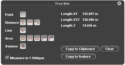
This page describes the Orbit desktop “Oblique View Measure” window and how to perform an oblique measurement.
For Orbit's generic 3D Measure capabilities, see Map 3D Measurements.
![]() Tabs > Oblique > 1st View Sidebar > Measure icon
Tabs > Oblique > 1st View Sidebar > Measure icon
Measure Mode
Measure in 1 Oblique \ Use DEM
Mobile mapping measurements can be done with a single click using a DTM or via triangulation using two images.
Indicate the desired measure mode via the “Measure in 1 Oblique” checkbox to use DTM (checked) or to measure via triangulation in 2 views (unchecked).
Information about the measure techniques and point cloud hover settings :
A DTM resource must be available for at least one of the currently opened views to enable the option “Measure in 1 Oblique”. If there is no DTM available for any of the opened views, this checkbox will be disabled.
Measure Functions
Here solely the dedicated Oblique measure functions are explained. For Orbit's generic 3D Measure capabilities, see Map 3D Measurements.
Distance
 Distance Horizontal measurement
Distance measurement, straight line between 2 coordinates.
How to measure : measure 2 coordinates.
Results : xy distance between measured points.
 Distance Vertical measurement with first measurement on the ground
Distance measurement, straight line between 2 coordinates.
How to measure : measure 2 coordinates, the first one on the ground.
Results : z distance between measured points.
Area
 Vertical rectangular area with ground
Vertical rectangular area measurement defined by 3 coordinates.
How to measure : (1) measure one side on ground, as distance, (2) measure any point on the opposite side.
Results : xyz area.
 Horizontal rectangular area with ground
Horizontal rectangular area measurement defined by 4 coordinates.
How to measure : (1) measure one point on ground, as distance, (2) measure one side at the desired height, as distance, (3) measure any point on the opposite side.
Results : xyz area, distance Z
 Free horizontal area with ground
Vertical rectangular area measurement defined by 3 coordinates.
How to measure : (1) measure one point on the ground(2) measure sequence of coordinates at the desired height, (3) stop
Results : xyz area, distance Z
Measure results
See Map 3D Measurements
How to measure
See Map 3D Measurements
Extract features
Using the measure window any measurement can be copied to the recorded dataset using the “Copy to feature” button.
- A measurment can only be copied to a dataset model of the same spatial component (points, polylines, areas).
- The CRS of the recorded datasets needs to be defined to perform the reprojection of the measurement to the dataset :
Coordinate Reference Systems > Dataset CRS - Depending the dataset structure of the recorded dataset 2D or 3D objects will be created :
Dataset Structure > Structure > Manage Models in Dataset > Coordinate
Also, the results of one measurement can be copied to clipboard using the omonime function.
